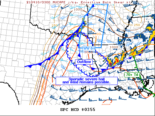
   Mesoscale Discussion 0355
   NWS Storm Prediction Center Norman OK
   1047 PM CDT Fri Apr 09 2021

   Areas affected...eastern Texas into western Louisiana

   Concerning...Severe Thunderstorm Watch 82...83...84...

   Valid 100347Z - 100545Z

   The severe weather threat for Severe Thunderstorm Watch 82, 83, 84
   continues.

   SUMMARY...Severe hail and wind remain possible across parts of east
   Texas into western Louisiana.

   DISCUSSION...A cold front continues to surge southeast toward the
   Arklatex and through the Metroplex. Meanwhile, outflow-cooled air
   remains over much of AR, northeast TX, and northern LA. Strong
   instability remains along the I-35 corridor, and though surface
   temperatures are cooling, strong elevated instability exists across
   the region, including atop the rain-cooled air mass.

   Isolated cells over east-central TX may persist for some time given
   the favorable downstream air mass, with large hail and perhaps
   damaging gusts. To the north, the squall line along the front has
   struggled to grow further, but potential remains given the strength
   of the lift. Elevated hail is possible north of the outflow
   boundary, with severe wind gusts more likely into the warmer air
   farther west.

   ..Jewell.. 04/10/2021

   ...Please see www.spc.noaa.gov for graphic product...

   ATTN...WFO...LCH...SHV...TSA...HGX...FWD...

   LAT...LON   32249626 33239629 33619587 33939526 33899487 33239428
               32449382 32059315 31749283 31329276 31249276 31159302
               30699379 30709445 31549565 31559563 32249626
|


 @NWSSPC