|
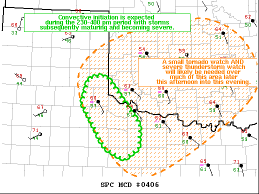
| Mesoscale Discussion 406 |
|
< Previous MD Next MD >
|

|
   Mesoscale Discussion 0406
   NWS Storm Prediction Center Norman OK
   1243 PM CDT Fri Apr 23 2021

   Areas affected...southeast TX Panhandle...western north-central
   TX...far southwest OK

   Concerning...Severe potential...Watch likely

   Valid 231743Z - 232015Z

   Probability of Watch Issuance...80 percent

   SUMMARY...Convective initiation is expected during the 230-400 pm
   period with storms subsequently maturing and becoming severe.  A
   large to giant hail risk (1 to 3+ inches in diameter) may accompany
   the stronger storms, especially late this afternoon; coincident in
   general timing with the peaking of a tornado threat.  Additional
   storm development and upscale growth will facilitate the transition
   to severe gusts becoming more common during the evening across
   south-central and central OK.

   DISCUSSION...Visible satellite imagery shows a cumulus field over
   the TX Low Rolling Plains east of the Caprock escarpment, where a
   dryline is becoming better defined from north to south.  Surface
   temperatures as of 1230 pm have warmed into the low 70s in Dickens
   County to the east of Lubbock and the northwestern rim of low 60s
   dewpoints arcs from 50 mi west of Abilene northeastward to near the
   Fredrick, OK WSR-88D location in southwest OK.

   Forecast soundings from 200 pm to 400 pm show the warming of the
   boundary layer to the east of the dryline at C11 (Seymour, TX) from
   the upper 60s to the mid 70s during the timeframe.  As a result of
   the warming, convective inhibition is essentially eroded.  The
   strengthening large-scale ascent associated with the approaching
   mid-level trough, will likely yield storms developing by mid
   afternoon across western north-central TX into far southwest OK.
   Strong effective shear and 2500-3000 J/kg MLCAPE will favor
   supercells with the stronger/persistent updrafts.  Large to giant
   hail may occur and possibly a tornado despite low-level shear
   relatively limited.  The transition to upscale growth in the form of
   a cluster and eventual band is expected this evening as the storms
   move east across south-central and central OK.

   ..Smith/Hart.. 04/23/2021

   ...Please see www.spc.noaa.gov for graphic product...

   ATTN...WFO...OUN...SJT...LUB...AMA...

   LAT...LON   34390071 34950054 35010007 33929916 33399917 33139956
               33400007 34390071
|
|
Top/All Mesoscale Discussions/Forecast Products/Home
|
|


