|
| Mesoscale Discussion 460 |
|
< Previous MD Next MD >
|
|
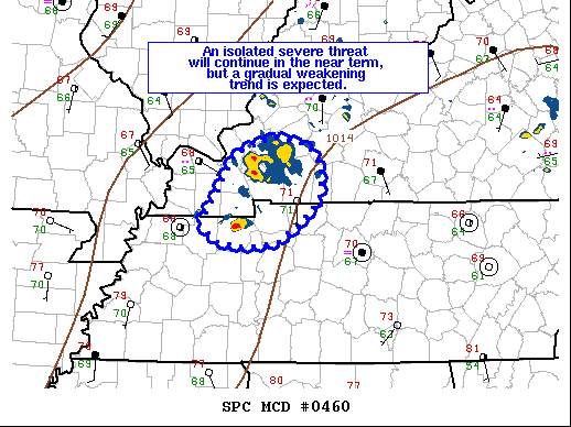
   Mesoscale Discussion 0460
   NWS Storm Prediction Center Norman OK
   0725 PM CDT Wed Apr 28 2021

   Areas affected...Western Kentucky and far Northwestern Tennessee

   Concerning...Severe Thunderstorm Watch 118...

   Valid 290025Z - 290130Z

   The severe weather threat for Severe Thunderstorm Watch 118
   continues.

   SUMMARY...The severe threat has begun to diminish across most of WW
   118, but an isolated cell across northwest Tennessee will continue
   to support a severe threat through at least 01 UTC.

   DISCUSSION...Recent satellite and radar trends have shown a gradual
   weakening of the convective line within WW 118 across western KY
   over the past 1-2 hours. The main severe threat has now become
   primarily limited to a discrete supercell that has emerged on the
   southern flank of the line and along the weak surface baroclinic
   zone in northwest TN. This cell has exhibited signs of low-level
   rotation, and recent observations from the KHPX VWP show 150 m2/s2
   0-1 km SRH remains in place ahead of the storm. Because of this, a
   severe hail/wind risk will persist at least through 01 UTC before
   diurnal cooling begins to increase inhibition. Additionally, a brief
   tornado will remain possible in the near-term given the
   environmental low-level shear. To the north of this supercell, a
   weak MCV has had occasional updraft pulses, but these have largely
   been transient and have posed minimal severe risk. While an instance
   of damaging wind remains possible, the severe potential will
   continue to decrease as this feature moves into a more stable air
   mass.

   ..Moore.. 04/29/2021

   ...Please see www.spc.noaa.gov for graphic product...

   ATTN...WFO...OHX...PAH...MEG...

   LAT...LON   36428874 36718855 37148831 37338780 37248736 36998718
               36678722 36438747 36248774 36198816 36258853 36428874
|
|
Top/All Mesoscale Discussions/Forecast Products/Home
|
|


 @NWSSPC