|
| Mesoscale Discussion 969 |
|
< Previous MD Next MD >
|
|
Mesoscale Discussion 0969
NWS Storm Prediction Center Norman OK
0255 PM CDT Mon Jun 14 2021
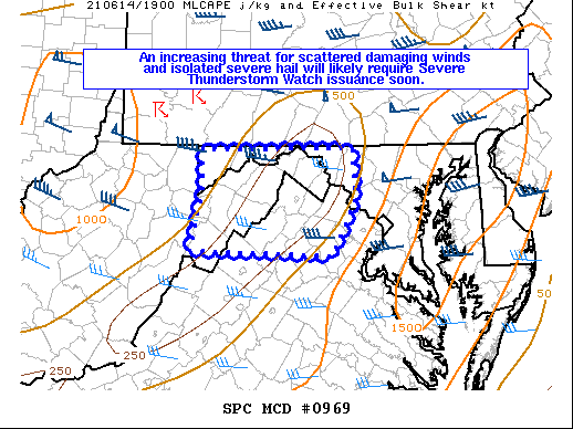
Areas affected...Portions of eastern WV...northern VA...and western
MD
Concerning...Severe potential...Severe Thunderstorm Watch likely
Valid 141955Z - 142100Z
Probability of Watch Issuance...95 percent
SUMMARY...An increasing threat for scattered damaging winds and
isolated severe hail will likely require Severe Thunderstorm Watch
issuance soon.
DISCUSSION...Ongoing convection across southwestern into central PA
should continue to spread southeastward into parts of western MD,
northern VA, and the eastern WV Panhandle through the remainder of
the afternoon and into the early evening. Strong mid-level flow
attendant to a shortwave trough is fostering 40-50 kt of deep-layer
shear, and mixed mode of supercells and multicells is expected. Even
though instability remains fairly limited across this region, it
should still be sufficient to support surface-based storms.
Scattered damaging winds and isolated marginally severe hail should
be the main threats, and Severe Thunderstorm Watch issuance is
likely soon.
..Gleason/Grams.. 06/14/2021
...Please see www.spc.noaa.gov for graphic product...
ATTN...WFO...LWX...PBZ...RLX...
LAT...LON 38637957 39287942 39677942 39697742 39167739 38597770
38637957
|
|
Top/All Mesoscale Discussions/Forecast Products/Home
|
|


 @NWSSPC