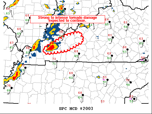
   Mesoscale Discussion 2003
   NWS Storm Prediction Center Norman OK
   1044 PM CST Fri Dec 10 2021

   Areas affected...Portions of western Kentucky.

   Concerning...Tornado Watch 554...

   Valid 110444Z - 110545Z

   The severe weather threat for Tornado Watch 554 continues.

   SUMMARY...Strong to intense tornado damage is expected to continue
   across portions of western Kentucky.

   DISCUSSION...The long-track supercell, now entering Hopkins county,
   Kentucky, has now had a nearly continuous TDS for over 3 hours with
   an average vRot over 70 knots. The radar presentation and downstream
   environment does not show any sign of weakening this storm in the
   near term. In fact, recent observations ahead of this supercell have
   shown temperature increases of 2 to 3 F and dewpoint increases of 2
   to 3F. This, combined with the cooling temperatures aloft, has
   actually increased instability ahead of this storm over the last 2
   hours. Warm sector winds have veered slightly in the last hour which
   has reduced low-level shear slightly. However, there is still
   significant turning between the surface and the southwesterly
   low-level jet, and therefore, despite this slightly weaker shear, it
   likely won't have much of an impact on storm tornadic potential.

   The likely catalysts for weakening this long-lived tornadic
   supercell will be eventual movement into low to mid 60s dewpoints
   and weaker instability, or storm interference as the storms to the
   west catch up with the lead supercell. Neither of these are expected
   to have an impact in the next hour, but may bring some reprieve
   after 06Z.

   ..Bentley.. 12/11/2021

   ...Please see www.spc.noaa.gov for graphic product...

   ATTN...WFO...LMK...PAH...

   LAT...LON   37138810 37648710 37788640 37478622 37118699 36978791
               36988807 37138810
|


 @NWSSPC