|
| Mesoscale Discussion 59 |
|
< Previous MD Next MD >
|
|
Mesoscale Discussion 0059
NWS Storm Prediction Center Norman OK
0206 PM CST Thu Jan 12 2023
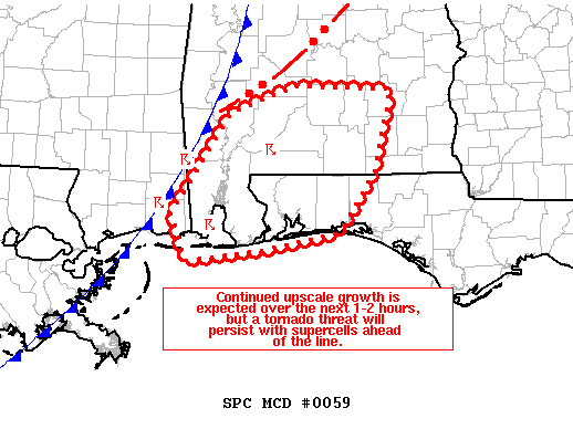
Areas affected...Southern Alabama and far western Florida Panhandle
Concerning...Tornado Watch 20...
Valid 122006Z - 122200Z
The severe weather threat for Tornado Watch 20 continues.
SUMMARY...Upscale growth into an organized squall line is expected
to continue over the next 1-2 hours across southern Alabama and the
far western Florida Panhandle. However, a tornado threat will
persist with supercells ahead of the line.
DISCUSSION...Latest radar trends from KMOB and GOES IR imagery show
convection gradually intensifying along a cold front across far
southeast MS into southwest AL. This trend is expected to continue
to over the next 1-2 hours as the cold front pushes east into
southern AL. Consequently, the potential for damaging winds may
increase given 30-40 knot shear vectors in the 0-2 to 0-3 km layers
orthogonal to the line. An embedded tornado threat may accompany the
line if a segment of balanced outflow can become established and
oriented meridionally.
The relatively higher tornado threat will remain associated with
isolated convection/supercells ahead of the line. A notable
supercell, currently over Conecuh county, AL, has maintained an
organized mesocyclone over the past hour and will continue to
propagate to the east/northeast over an environment with favorable
low-level moisture (dewpoints in the mid 60s) and 0-1 km SRH near
200 m2/s2. Furthermore, supercell propagation vectors suggest this
cell will remain ahead of the line for roughly the next 1-2 hours
with relatively few storm interactions, which will aid in
maintaining the tornado potential.
..Moore.. 01/12/2023
...Please see www.spc.noaa.gov for graphic product...
ATTN...WFO...TAE...BMX...MOB...LIX...
LAT...LON 30578856 31658785 31948707 31908587 31028608 30398651
30228737 30098838 30578856
|
|
Top/All Mesoscale Discussions/Forecast Products/Home
|
|


 @NWSSPC