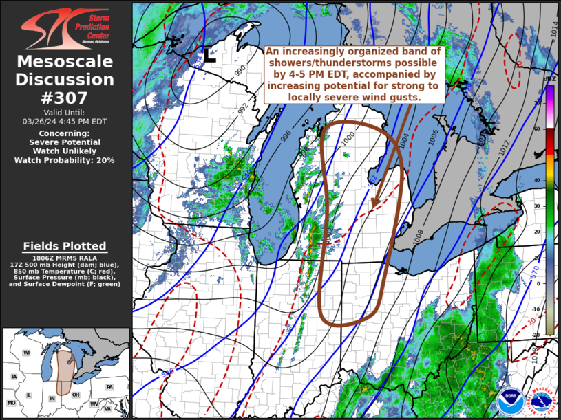
   Mesoscale Discussion 0307
   NWS Storm Prediction Center Norman OK
   0108 PM CDT Tue Mar 26 2024

   Areas affected...much of lower Michigan...northeastern
   Indiana...northwestern Ohio

   Concerning...Severe potential...Watch unlikely

   Valid 261808Z - 262045Z

   Probability of Watch Issuance...20 percent

   SUMMARY...An increasingly organized band of showers, and developing
   thunderstorms, may be accompanied by increasing potential for strong
   to locally severe surface gusts by 4-5 PM EDT.  It is still not
   clear that a severe weather watch is needed, but trends are being
   monitored for this possibility.

   DISCUSSION...Weak destabilization within a narrow pre-frontal
   corridor of low-level warming and moistening, coupled with
   large-scale ascent aided by warm advection, has contributed to
   increasing showers across western lower Michigan southward toward
   the Indianapolis IN vicinity.  Some lightning has recently been
   noted southeast of South Bend, but low-level lapse rates are still
   relatively modest and the moistening is only contributing to very
   weak CAPE.

   This may be slow to improve, but breaks in cloud cover may allow for
   at least some continuing insolation during the next few hours.
   Perhaps more notably, within the left exit region of an intensifying
    mid-level jet (in excess of 100 kt around 500 mb) nosing
   north-northeastward through the lower Ohio Valley, strengthening
   low-level frontogenetic forcing is forecast along the eastward
   advancing front across central lower Michigan through the
   Indiana/Ohio border area by 20-21Z.  This may support a
   consolidating and deepening band of convection with increasing
   potential to produce lightning.

   In the presence of fairly strong (and strongly sheared)
   south-southwesterly lower/mid-tropospheric flow (including 40-50+ kt
   mean ambient flow in the lowest 3-6 km AGL), activity may become
   increasingly organized.  Downward mixing of momentum may contribute
   to potentially damaging wind gusts reaching the surface in
   northeastward surging segments, while the line advances eastward
   toward the lower Great Lakes region through late afternoon.

   ..Kerr/Hart.. 03/26/2024

   ...Please see www.spc.noaa.gov for graphic product...

   ATTN...WFO...CLE...ILN...DTX...APX...IWX...GRR...

   LAT...LON   40428544 42978529 44938539 44928356 43948281 41398341
               40408392 40428544
|


 @NWSSPC