|
| Mesoscale Discussion 340 |
|
< Previous MD Next MD >
|
|
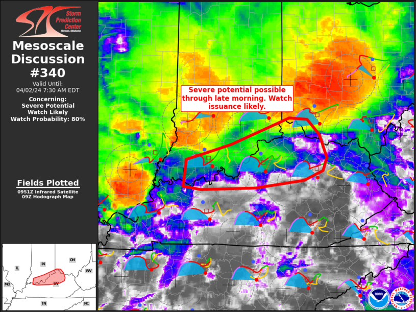
   Mesoscale Discussion 0340
   NWS Storm Prediction Center Norman OK
   0455 AM CDT Tue Apr 02 2024

   Areas affected...southern Indiana...northern Kentucky and southwest
   Ohio

   Concerning...Severe potential...Watch likely

   Valid 020955Z - 021130Z

   Probability of Watch Issuance...80 percent

   SUMMARY...Severe thunderstorm potential is expected through late
   morning across parts of northern Kentucky, southern Indiana and
   southwest Ohio. Damaging gusts and a tornado or two will be possible
   with this activity and a watch will likely be needed in the next
   hour.

   DISCUSSION...Upstream convection across southern IL/western KY into
   southwest IN will continue to spread generally east this morning.
   While instability remains modest across the region, strong vertical
   shear is present and favorable for continued organized convection.
   An increase in lightning trends across southern IL and the
   background CAPE/shear environment suggest this activity will
   continue within the vicinity of an effective outflow/stationary
   front draped across southern IL/IN/southwest OH. Damaging gusts will
   be possible with generally linear/bowing storm mode. However,
   enlarged, curved low-level hodographs and 0-1 km SRH greater than
   200 m2/s2 suggest some tornado risk also will accompany this
   activity. A tornado watch downstream from WW 72 will likely be
   needed in the next hour. It should be noted that additional severe
   potential will overspread this same area again later this afternoon.

   ..Leitman/Smith.. 04/02/2024

   ...Please see www.spc.noaa.gov for graphic product...

   ATTN...WFO...JKL...ILN...LMK...IND...PAH...

   LAT...LON   38348725 38448684 38658611 39188463 39148416 38848386
               38378367 38128378 37938425 37778548 37748687 37798731
               38348725
|
|
Top/All Mesoscale Discussions/Forecast Products/Home
|
|


 @NWSSPC