|
| Mesoscale Discussion 347 |
|
< Previous MD Next MD >
|
|
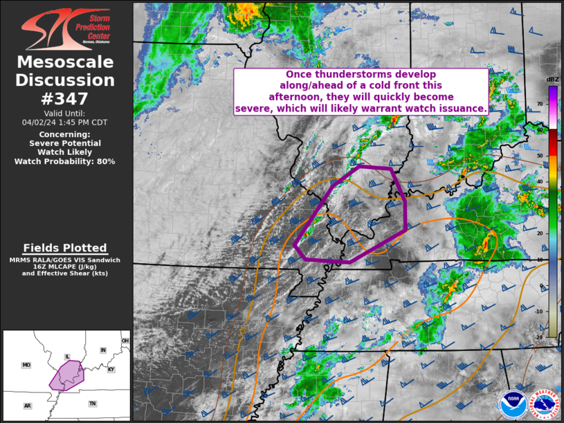
   Mesoscale Discussion 0347
   NWS Storm Prediction Center Norman OK
   1148 AM CDT Tue Apr 02 2024

   Areas affected...Portions of southeastern MO...southern IL...western
   KY...and extreme southwestern IN

   Concerning...Severe potential...Watch likely

   Valid 021648Z - 021845Z

   Probability of Watch Issuance...80 percent

   SUMMARY...Once thunderstorms develop along/ahead of a cold front,
   they will quickly become severe, which will likely warrant watch
   issuance.

   DISCUSSION...Cu is gradually becoming more agitated along a surface
   wind shift line across southeastern MO, and convective initiation
   appears likely within the next hour or so. The airmass downstream
   has become at least weakly unstable, with surface temperatures
   warming into the mid 70s, with surface dewpoints also increasing
   into the mid to upper 60s. Corresponding MLCAPE generally ranges
   from 500-1000 J/kg at the moment, but continued daytime heating of
   this moist airmass should allow for additional destabilization
   through the afternoon. Very strong effective bulk shear of 50-60+ kt
   will easily support supercells with associated threat for large
   hail. Damaging winds will also be possible with any clusters that
   can consolidate along the wind shift line and spread eastward. The
   tornado threat remains somewhat unclear, particularly with northward
   extent into southern IL/IN where the airmass is still attempting to
   destabilize. Regardless, recent VWPs from KPAH/KVWX show ample
   low-level shear present to support updraft rotation and some risk
   for tornadoes with any supercells that can be sustained. Watch
   issuance will likely be needed once convective initiation appears
   imminent.

   ..Gleason/Thompson.. 04/02/2024

   ...Please see www.spc.noaa.gov for graphic product...

   ATTN...WFO...PAH...

   LAT...LON   36949026 38038938 38408876 38358802 37758770 37218770
               36628898 36689000 36949026
|
|
Top/All Mesoscale Discussions/Forecast Products/Home
|
|


 @NWSSPC