|
| Mesoscale Discussion 360 |
|
< Previous MD Next MD >
|
|
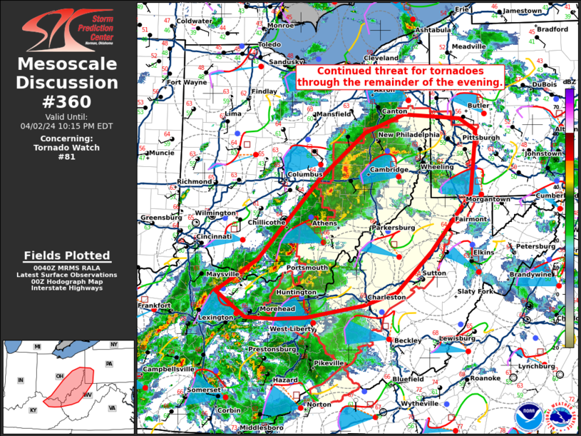
   Mesoscale Discussion 0360
   NWS Storm Prediction Center Norman OK
   0742 PM CDT Tue Apr 02 2024

   Areas affected...eastern Ohio...southwest Pennsylvania...and western
   West Virginia

   Concerning...Tornado Watch 81...

   Valid 030042Z - 030215Z

   The severe weather threat for Tornado Watch 81 continues.

   SUMMARY...There is a continued threat for tornadoes through the
   evening within tornado watch 81.

   DISCUSSION...A cluster of storms with embedded supercells extends
   from east-central Ohio into southern Ohio. Shear ahead of these
   storms is very favorable with nearly 100% streamwise vorticity in
   the lowest 1 km at the RLX and PBZ VWP. Instability is the primary
   limiting factor with dewpoints only in the upper 50s to low 60s and
   temperatures in the low to mid-60s. However, despite the limited
   buoyancy, brief tornadoes have been present with several of these
   storms and a similar threat will continue into the late evening.
   Shear will increase further as the low-level jet intensifies which
   will likely maintain the threat into the early overnight hours.

   ..Bentley.. 04/03/2024

   ...Please see www.spc.noaa.gov for graphic product...

   ATTN...WFO...PBZ...RLX...CLE...JKL...ILN...LMK...

   LAT...LON   38478415 38908346 39978241 40588164 40828097 40758001
               40607974 39767983 39008052 38478110 38298168 38138264
               38118316 38138366 38478415
|
|
Top/All Mesoscale Discussions/Forecast Products/Home
|
|


 @NWSSPC