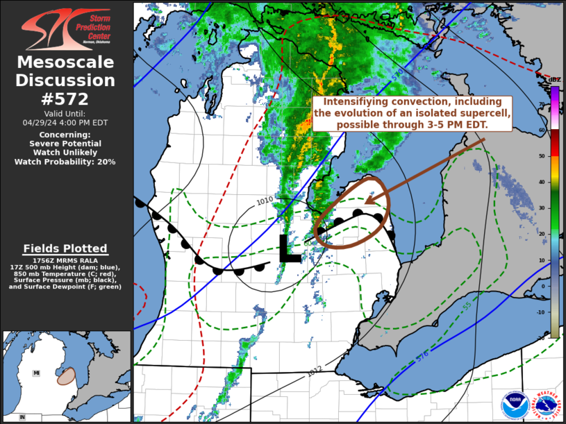
   Mesoscale Discussion 0572
   NWS Storm Prediction Center Norman OK
   1258 PM CDT Mon Apr 29 2024

   Areas affected...the Michigan Thumb vicinity

   Concerning...Severe potential...Watch unlikely

   Valid 291758Z - 292000Z

   Probability of Watch Issuance...20 percent

   SUMMARY...The evolution of an isolated supercell accompanied by at
   least some potential for a tornado, in addition severe hail and
   wind, appears possible across the Michigan Thumb vicinity near Bad
   Axe through 3-5 PM EDT.

   DISCUSSION...Downstream of larger-scale mid-level troughing, with an
   embedded low, migrating northeastward into/through the Upper
   Midwest/Great Lakes vicinity, a strong south-southwesterly mid-level
   jet (40-70 kt in the 700-500 mb layer) is in the process of
   propagating across lower Michigan.  In association with this
   feature, an area of stronger surface pressure falls (2-3+ mb 2
   hourly) has generally begun to shift across Lake Huron, but still
   extends along an axis as far south as the Flint MI vicinity.  This
   is near a weak surface frontal low which is forecast to migrate
   across and northeast of the Bad Axe vicinity through 19-21Z.

   South of the front, boundary-layer moistening (including surface dew
   points around 60f) has been sufficient to contribute to weak
   destabilization (including mixed-layer CAPE increasing up to 500
   J/kg).  Although further heating and mixing may reduce this some to
   the south of the front, this may be maintained along the front, just
   ahead of the low, which may gradually provide a focus for
   intensifying convection.  Given the strength of the vertical shear,
   including sizable clockwise-curved low-level hodographs, and
   localized forcing for ascent, the evolution of a supercell appears
   possible, which may pose at least some risk for producing a tornado,
   in addition to marginally severe hail and wind.

   ..Kerr/Hart.. 04/29/2024

   ...Please see www.spc.noaa.gov for graphic product...

   ATTN...WFO...DTX...

   LAT...LON   43518375 44018294 43788262 43438274 43228323 43248368
               43518375
|


 @NWSSPC