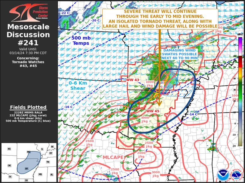
   Mesoscale Discussion 0241
   NWS Storm Prediction Center Norman OK
   0531 PM CDT Thu Mar 14 2024

   Areas affected...Southeast Missouri...Arkansas

   Concerning...Tornado Watch 43...45...

   Valid 142231Z - 150030Z

   The severe weather threat for Tornado Watch 43, 45 continues.

   SUMMARY...A severe threat will continue across southeast Missouri
   and Arkansas. Wind damage, large hail and an isolated tornado threat
   is expected over the next few hours.

   DISCUSSION...The latest high-resolution radar from Springfield,
   Missouri shows a well-developed line segment extending southward
   across south-central Missouri and north-central Arkansas. An intense
   bowing segment is located at the northern end of the line across
   Dent, Shannon, and Howell Counties. This feature will move eastward
   across southeastern Missouri over the next hour. The forward speed
   of the bow was measured at 47 knots, suggesting that wind damage
   will be likely along the leading edge. Further south into northern
   and western Arkansas, a cluster of strong to severe storms is
   ongoing. As convective coverage increases over the next hour,
   organization into a line will be possible. If a cold pool can
   develop, another bowing segment with wind damage potential would be
   possible. Large hail, and an isolated tornado threat may also
   develop with discrete storms that obtain supercell structure, and
   along the leading edge of any organized bow.

   ..Broyles.. 03/14/2024

   ...Please see www.spc.noaa.gov for graphic product...

   ATTN...WFO...PAH...MEG...LSX...LZK...SGF...SHV...TSA...

   LAT...LON   34299438 33959394 33899336 34069261 34969079 35968982
               36888947 37528965 37729036 37769108 37759156 37599196
               37029225 36539259 36119314 35709410 35189443 34729449
               34299438
|


 @NWSSPC