|
| Mesoscale Discussion 285 |
|
< Previous MD Next MD >
|
|
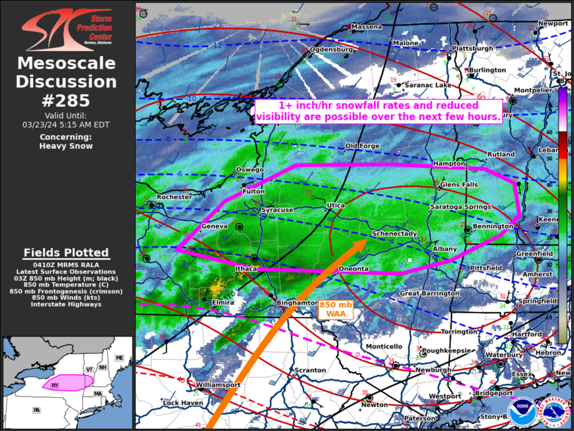
   Mesoscale Discussion 0285
   NWS Storm Prediction Center Norman OK
   1113 PM CDT Fri Mar 22 2024

   Areas affected...portions of central and eastern New York into
   southern Vermont

   Concerning...Heavy snow

   Valid 230413Z - 230915Z

   SUMMARY...Periods of heavy snow are likely over the next several
   hours. 1+ inch/hr snowfall rates and reduced visibility are possible
   in the heaviest snow bands.

   DISCUSSION...925-850 mb warm-air advection continues to transport
   moisture into a sub-freezing troposphere amid a gradually amplifying
   mid-level trough approaching from the west. A shield of widespread
   moderate snow is already overspreading much of central and southern
   NY, with a couple instances of heavy snow already reported via
   surface observations. Increasing magnitudes and coverage of heavier
   snowfall rates (i.e. 1+ inches/hr) are expected to continue through
   the night as the approaching mid-level trough further amplifies and
   low-level warm-air advection persists.

   ..Squitieri.. 03/23/2024

   ...Please see www.spc.noaa.gov for graphic product...

   ATTN...WFO...BTV...ALY...BGM...BUF...

   LAT...LON   42667729 43177664 43567563 43577427 43507298 43357257
               43027251 42837279 42587348 42457418 42487620 42667729
|
|
Top/All Mesoscale Discussions/Forecast Products/Home
|
|


 @NWSSPC