|
| Mesoscale Discussion 290 |
|
< Previous MD Next MD >
|
|
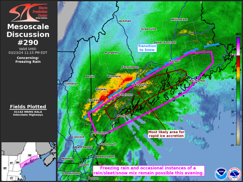
   Mesoscale Discussion 0290
   NWS Storm Prediction Center Norman OK
   0817 PM CDT Sat Mar 23 2024

   Areas affected...Portions of southern Maine

   Concerning...Freezing rain

   Valid 240117Z - 240315Z

   SUMMARY...Freezing rain will remain a concern across portions of
   southern Maine for at least the next few hours. Occasional instances
   of sleet or snow are also possible.

   DISCUSSION...KGYX and KCBW dual polarimetric radar data continues to
   show a stationary transition zone between rain and a wintry mix,
   roughly oriented from York to northern Washington County Maine. This
   boundary should only slowly progress eastward over the next few
   hours as the low-level cyclone continues to parallel the boundary
   orientation and traverse the Atlantic Coastline. While snow
   (occasionally heavy) will continue to the north of the transition
   zone, freezing rain and occasional instances of a rain/snow/sleet
   mix should persist nearer to the Maine coastline. Here, surface
   temperatures hover around the freezing mark, but temperatures above
   the surface have warmed above freezing given strong WAA. 0.05 inch/3
   hour ice accretion rates are most likely 20+ nautical miles inland,
   where surface temperatures remain around 31-32 F, which is in
   agreement with some of the latest high-resolution model guidance.

   ..Squitieri.. 03/24/2024

   ...Please see www.spc.noaa.gov for graphic product...

   ATTN...WFO...CAR...GYX...

   LAT...LON   43627100 43777109 43787092 43927067 44137024 44426959
               44726887 45016814 45016752 44806749 44206827 43876908
               43626980 43417034 43317063 43367085 43627100
|
|
Top/All Mesoscale Discussions/Forecast Products/Home
|
|


 @NWSSPC