|
| Mesoscale Discussion 295 |
|
< Previous MD Next MD >
|
|
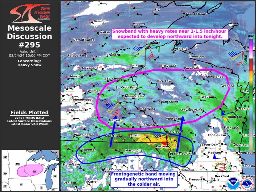
   Mesoscale Discussion 0295
   NWS Storm Prediction Center Norman OK
   0504 PM CDT Sun Mar 24 2024

   Areas affected...Parts of southeastern Minnesota and
   northern/central Wisconsin

   Concerning...Heavy snow

   Valid 242204Z - 250300Z

   SUMMARY...A snowband with eventual heavy rates near 1-1.5 inch/hour
   is expected to move northward across parts of southeastern Minnesota
   and northern/central Wisconsin into tonight. The onset of heavier
   rates is expected in the 23Z-04Z time frame.

   DISCUSSION...KARX radar data and mesoanalysis as of 22Z indicate a
   well-defined frontogenetic band moving northward across far northern
   IA, southern MN, and southwest WI. This band is generally located
   along the northern periphery of a swath of 40-50-kt 1-km flow per
   regional VWP data, which also shows a large clockwise-curved
   low-level hodograph -- indicative of strong low-level warm-air
   advection. The associated low-level warm nose is yielding melting of
   hydrometeors beneath the snowband (and a robust bright-banding
   signature), with light to moderate snowfall rates thus far.

   With time, the band will continue northward into a region of colder
   low-level air, and additional low-level cooling should be aided by
   nocturnal effects and wet-bulbing. As a result, snowfall rates
   should eventually increase to near 1-1.5 inch/hour as the snowband
   moves into the increasingly cold air. There is some uncertainty on
   how widespread these heavier rates will be (especially in the next
   couple of hours), due to the marginally cold temperatures and much
   of the frontogenetic ascent remaining below the dendritic growth
   zone. Nevertheless, the heavy-snow potential should increase in the
   23Z-04Z time frame.

   ..Weinman.. 03/24/2024

   ...Please see www.spc.noaa.gov for graphic product...

   ATTN...WFO...GRB...DLH...ARX...MPX...

   LAT...LON   44059117 43959249 43979386 44239442 44649458 45019452
               45409416 45709334 45959186 45928898 45698837 45288825
               44718867 44218993 44059117
|
|
Top/All Mesoscale Discussions/Forecast Products/Home
|
|


 @NWSSPC