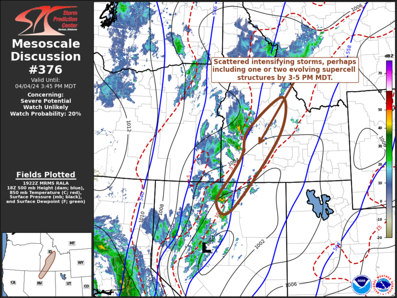
   Mesoscale Discussion 0376
   NWS Storm Prediction Center Norman OK
   0224 PM CDT Thu Apr 04 2024

   Areas affected...parts of north central Nevada into the Sawtooth
   Mountains vicinity of south central Idaho

   Concerning...Severe potential...Watch unlikely

   Valid 041924Z - 042145Z

   CORRECTED WORDING IN SECOND PARAGRAPH OF DISCUSSION

   Probability of Watch Issuance...20 percent

   SUMMARY...One or two supercells may gradually develop within a
   narrow pre-frontal corridor, and pose at least some risk for severe
   hail and wind by 3-5 PM MDT.  While the need for a watch is not
   currently anticipated, trends are being monitored.

   DISCUSSION...Latest objective analysis suggests that more rapid
   boundary-layer destabilization is now underway, particularly in a
   narrow pre-frontal corridor west of Twin Falls toward the Sawtooth
   Mountains vicinity, west of Sun Valley.  This is occurring in
   response to continuing insolation and low-level warm advection,
   beneath cool mid-levels which may contribute to mixed-layer CAPE
   increasing in excess of 500 J/kg within the next few hours.  As this
   occurs, models indicate that frontogenetic forcing for ascent will
   also strengthen along this corridor, downstream of a developing
   frontal wave migrating northeastward out of the Great Basin.

   An area of intensifying thunderstorm development is already ongoing
   to the southwest of Owyhee NV, and this activity seems likely to
   continue to gradually strengthen and organize through 21-23Z, while
   propagating north-northeastward within a strongly sheared
   environment beneath an 80-100+ kt south-southwesterly 300 mb jet.
   With increasing inflow of the destabilizing boundary-layer air, one
   or two supercell structures may evolve, accompanied by at least some
   risk for severe hail and locally damaging wind gusts.

   ..Kerr/Thompson.. 04/04/2024

   ...Please see www.spc.noaa.gov for graphic product...

   ATTN...WFO...PIH...MSO...BOI...LKN...

   LAT...LON   44881413 43561430 41031651 41331720 42281650 42961602
               43791576 44881413
|


 @NWSSPC