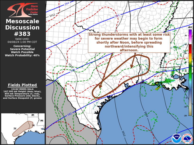
   Mesoscale Discussion 0383
   NWS Storm Prediction Center Norman OK
   1026 AM CDT Mon Apr 08 2024

   Areas affected...parts of the mid/upper Texas coastal plain and
   adjacent western Louisiana

   Concerning...Severe potential...Watch possible

   Valid 081526Z - 081800Z

   Probability of Watch Issuance...40 percent

   SUMMARY...Widely scattered strong thunderstorms may begin to form
   across and inland of mid/upper Texas and southwest Louisiana coastal
   areas by early afternoon.  This may be accompanied by at least some
   risk for severe hail, and perhaps a tornado, before storms increase
   and intensify with a more notable increase in severe weather
   potential later this afternoon, as activity spreads toward
   central/northern Texas.

   DISCUSSION...An initial influx of low-level moisture, which
   accompanied a significant cyclone now weakening over the Upper
   Midwest vicinity, lingers along and south of a stalling/weakening
   boundary now extending across the lower Mississippi Valley into
   southeastern Texas.  This includes surface dew points ranging from
   the lower 70s across the northwestern Gulf into immediate Texas Gulf
   coastal areas, and upper 60s F further inland across the coastal
   plain, which will begin to advect northwestward and northward
   through the day, downstream of a significant short wave trough
   turning eastward across the Southwest.

   Beneath the northeastern periphery of a plume of elevated
   mixed-layer air advecting across the lower Rio Grande Valley, this
   moisture already appears to be contributing to sizable CAPE on the
   order of 2000 J/kg.  This probably will increase at least a bit
   further through the day, as thin spots and breaks in the overcast
   allow for some insolation.

   At the same time, models indicate strengthening of southwesterly
   flow into mid-levels (30-50+ kts in the 700-500 mb layer), beneath a
   strong upper jet emanating from the subtropical eastern Pacific, and
   by early afternoon the environment will become increasingly
   conducive to potential for supercells.  Various model output
   suggests that at least widely scattered thunderstorms may begin to
   form across and inland of coastal areas by around 17-18Z, before
   gradually intensifying and increasing further within northwestward
   and northward spreading large-scale ascent aided by low-level warm
   advection.

   While it is possible that it may take a couple of hours for a more
   substantive increase in severe weather potential to develop, as
   storms acquire better inflow of more unstable near-surface air,
   initial storms may pose at least some risk for severe hail.  The
   risk for a brief tornado may also not be completely negligible,
   though clockwise curved low-level hodographs will initially be weak.

   ..Kerr/Gleason.. 04/08/2024

   ...Please see www.spc.noaa.gov for graphic product...

   ATTN...WFO...LCH...SHV...HGX...CRP...EWX...

   LAT...LON   29189796 30279668 31559496 32079393 31989315 31709266
               30679286 30279415 29849513 29319588 28649711 28589781
               29189796
|


 @NWSSPC