|
| Mesoscale Discussion 390 |
|
< Previous MD Next MD >
|
|
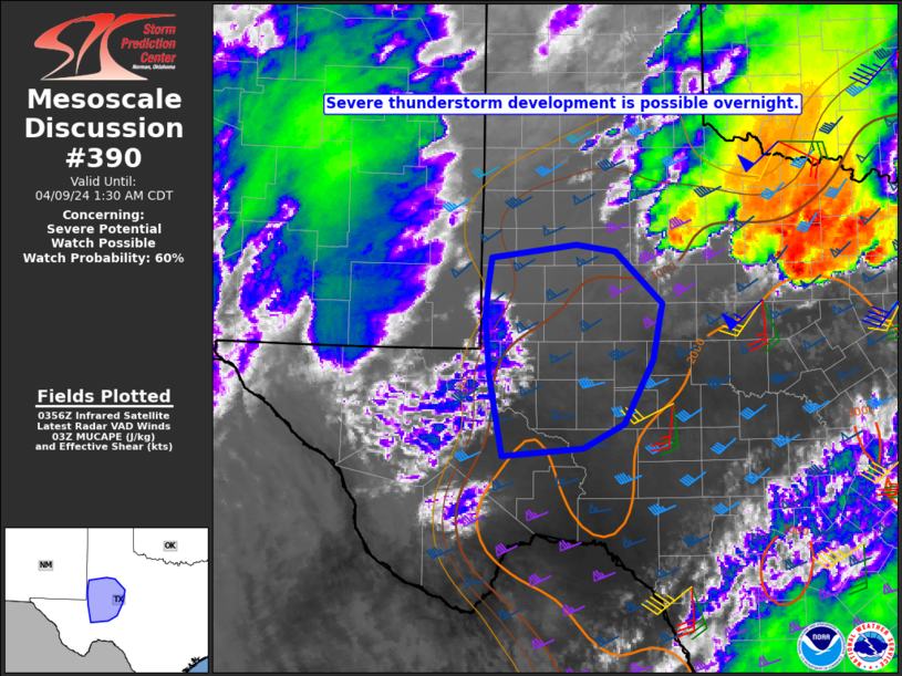
   Mesoscale Discussion 0390
   NWS Storm Prediction Center Norman OK
   1059 PM CDT Mon Apr 08 2024

   Areas affected...TX Permian Basin vicinity

   Concerning...Severe potential...Watch possible

   Valid 090359Z - 090630Z

   Probability of Watch Issuance...60 percent

   SUMMARY...Severe thunderstorm development will be possible
   overnight, with a threat of large hail.

   DISCUSSION...Low-level moisture continues to stream northwestward
   late this evening into portions of the TX Permian Basin region.
   Meanwhile, WV and IR imagery suggests that ascent related to the
   deep upper-level trough over the Southwest is beginning to
   overspread the region. While timing remains uncertain, storm
   development will become increasingly likely overnight, especially
   near/north of a southward-moving cold front. Steep midlevel lapse
   rates, MUCAPE increasing into the 1000-2000 J/kg range, and
   effective shear of 40+ kts will support elevated supercell
   potential, with an attendant threat of large hail in the 1.5 - 2
   inch diameter range.

   Severe-storm coverage remains somewhat uncertain overnight and could
   remain rather isolated, but eventual watch issuance is possible
   given the potential for elevated supercells.

   ..Dean/Hart.. 04/09/2024

   ...Please see www.spc.noaa.gov for graphic product...

   ATTN...WFO...SJT...LUB...MAF...

   LAT...LON   32360300 32700297 33040291 33200177 33110124 32510060
               31860073 31130112 30860168 30770276 31710295 32360300
|
|
Top/All Mesoscale Discussions/Forecast Products/Home
|
|


 @NWSSPC