|
| Mesoscale Discussion 574 |
|
< Previous MD Next MD >
|
|
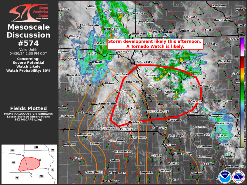
   Mesoscale Discussion 0574
   NWS Storm Prediction Center Norman OK
   0105 PM CDT Tue Apr 30 2024

   Areas affected...portions of eastern Nebraska far northeastern
   Kansas...western Iowa and northwest Missouri

   Concerning...Severe potential...Watch likely

   Valid 301805Z - 301930Z

   Probability of Watch Issuance...80 percent

   SUMMARY...Isolated storm development is possible by 19-20z across
   parts of eastern NE and far northeast KS. Initially supercells may
   support a risk for all hazards.

   DISCUSSION...As of 1800 UTC, visible imagery showed deepening
   cumulus towers east of a weak surface cyclone across portions of
   eastern NE and northern KS. Signs of subtle forcing for ascent are
   beginning to overspread this regional ahead of a low-amplitude
   shortwave trough over western NE. Amidst increasing ascent and
   strong diurnal heating, remaining MLCINH is rapidly eroding.
   Observational trends and Hi-res model guidance indicate isolated
   storm development is possible as early as 19-20z across parts of
   eastern NE and far northern KS. Upper 50s to low 60s F surface
   dewpoints and steep mid-level lapse rates are supporting MLCAPE of
   1500-2000 J/kg. Given the potential for strong updrafts,
   organization into initial supercells is expected with 40-50 kt of
   effective shear observed on area VADs. Isolated storms will be
   capable of large to very large hail and damaging wind gusts
   initially. Tornadoes will also be possible, especially near the warm
   front farther east and south, where lower cloud bases and stronger
   low-level shear are favored.

   While the initial storm mode is expected to be primarily
   supercellular, the surface cold front will impinge on the western
   warm sector later this afternoon. The increase in linear forcing and
   additional storm development through the afternoon suggests storm
   interactions may favor upscale growth into short line segments and
   clusters with time. While, there is some uncertainty on storm mode,
   a tornado watch is likely this afternoon.

   ..Lyons/Hart.. 04/30/2024

   ...Please see www.spc.noaa.gov for graphic product...

   ATTN...WFO...DMX...EAX...FSD...OAX...GID...

   LAT...LON   41959701 42469631 42469550 42359453 42219392 41989340
               41619319 41189322 40779364 40549435 40359649 40179724
               40399761 40569757 41959701
|
|
Top/All Mesoscale Discussions/Forecast Products/Home
|
|


 @NWSSPC