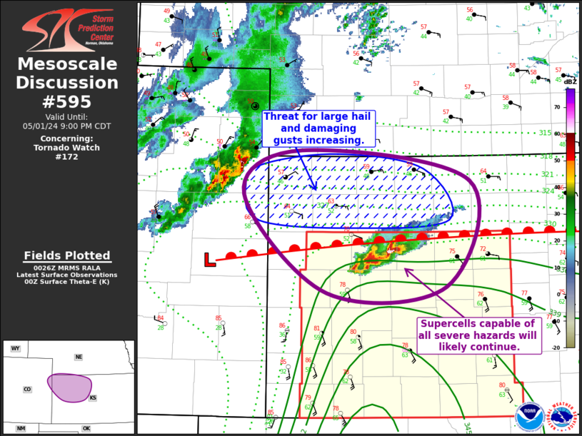
   Mesoscale Discussion 0595
   NWS Storm Prediction Center Norman OK
   0728 PM CDT Wed May 01 2024

   Areas affected...Far Northeast CO...Western and Central KS

   Concerning...Tornado Watch 172...

   Valid 020028Z - 020200Z

   The severe weather threat for Tornado Watch 172 continues.

   SUMMARY...Supercells over western KS are expected to persist, with
   the potential for all severe hazards. An additional severe threat
   may exist farther north across northwest and north-central KS,
   downstream of the cluster coming out of northeast CO, and additional
   watch may be needed.

   DISCUSSION...Regional radar imagery continues to show pair of
   well-organized supercells over Logan and Gove Counties in western
   KS. These supercells are very close to the warm front extending from
   west to east across the KS, which is likely contributing to both
   low-level moisture convergence and low-level vorticity. Interactions
   between these two storms may contribute to some fluctuations in
   storm intensity, but the overall environment is expected to remain
   supportive of storm persistence. Additionally, increasing low-level
   flow over the next few hours will lengthen low-level hodographs,
   with the low-level kinematic environment becoming more favorable for
   tornadoes.

   Regional radar imagery also shows a more linear, forward-propagating
   cluster of storms moving out of far northeast CO towards far
   northwest KS. This activity is expected to continue moving
   southeastward, with the strengthening low-level flow and associated
   isentropic ascent contributing to storm persistence. Current
   trajectory takes this cluster north of the warm front, but some
   interaction with this frontal boundary could occur with more
   southeastward extent. Hail appears to be the predominant risk with
   this cluster, although some damaging gusts are possible as well,
   particularly with eastward/southeastward extent. A watch may be
   needed north of Tornado Watch 172 to address this threat.

   ..Mosier/Guyer.. 05/02/2024

   ...Please see www.spc.noaa.gov for graphic product...

   ATTN...WFO...GID...DDC...GLD...

   LAT...LON   39550240 40060155 39719906 38499942 38420118 39550240
|


 @NWSSPC