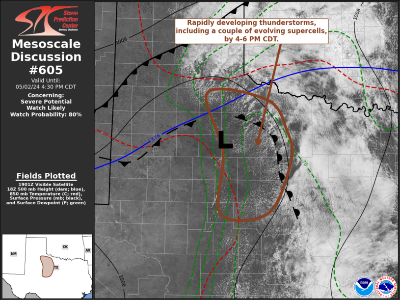
   Mesoscale Discussion 0605
   NWS Storm Prediction Center Norman OK
   0207 PM CDT Thu May 02 2024

   Areas affected...parts of northwest Texas

   Concerning...Severe potential...Watch likely

   Valid 021907Z - 022130Z

   Probability of Watch Issuance...80 percent

   SUMMARY...Intensifying thunderstorm development, including a couple
   of evolving supercells with potential to producing large hail in
   excess of 2 inches in diameter and perhaps a tornado or two, appears
   increasingly likely by 4-6 PM CDT.

   DISCUSSION...A zone of differential surface heating continues to
   become better defined across parts of the Texas South Plains into
   central Texas, with stronger boundary-layer heating and mixing
   ongoing to the west of air impacted by overnight convection.  A weak
   surface low appears to be developing along this boundary between
   Childress and Abilene, with a developing area of strengthening warm
   advection to its east and southeast.  This appears to be
   contributing to ongoing gradually deepening convective development,
   beneath a plume of warm and capping elevate mixed-layer air.

   Along and east of a sharpening dryline, to the south of the low, a
   seasonably moist boundary-layer is becoming characterized by
   mixed-layer CAPE up to 3000 J/kg.  Low-level wind fields are light,
   but veering with height beneath 25-50 kt flow in the 500-300 mb
   layer appears to be contributing to sufficient shear for supercells.

   Although potential mid/upper forcing for thunderstorm development
   remains unclear, latest model output suggests that lift associated
   with warm advection, coupled with the approach of convective
   temperatures, will contribute to increasing probabilities for
   thunderstorm initiation through 21-23Z.  Once this occurs,
   intensification may be rapid, with stronger storms becoming capable
   of producing large hail and perhaps posing a risk for tornadoes.

   ..Kerr/Hart.. 05/02/2024

   ...Please see www.spc.noaa.gov for graphic product...

   ATTN...WFO...FWD...OUN...SJT...LUB...

   LAT...LON   31870052 33060048 34210085 34079944 33479900 32899890
               31879943 31870052
|


 @NWSSPC