|
| Mesoscale Discussion 673 |
|
< Previous MD Next MD >
|
|
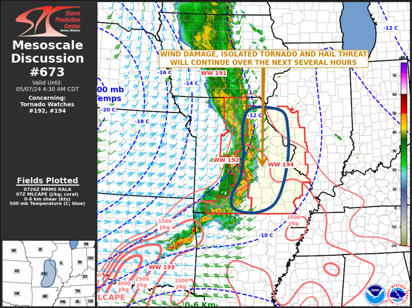
   Mesoscale Discussion 0673
   NWS Storm Prediction Center Norman OK
   0229 AM CDT Tue May 07 2024

   Areas affected...Missouri...Far Western Illinois

   Concerning...Tornado Watch 192...194...

   Valid 070729Z - 070930Z

   The severe weather threat for Tornado Watch 192, 194 continues.

   SUMMARY...A potential for wind damage, a few tornadoes, and hail
   will continue along a line of strong to severe storms moving through
   Missouri. The severe threat will eventually affect parts of western
   Illinois later tonight.

   DISCUSSION...The latest hi-resolution radar imagery shows a
   well-developed severe linear MCS, with several embedded rotating
   cells and bowing line segments. This line is moving eastward into
   moderate instability, with the RAP analyzing MLCAPE around 1500 J/kg
   across much of eastern Missouri. In addition, WSR-88D VWPs ahead of
   the line near St Louis have 0-6 km shear near 35 knots, with 0-3 km
   storm-relative helicity near 550 m2/s2. This environment will
   continue to support a wind damage and isolated tornado threat with
   the rotating elements within the line. These stronger cells could
   also be associated with hail.

   ..Broyles.. 05/07/2024

   ...Please see www.spc.noaa.gov for graphic product...

   ATTN...WFO...PAH...ILX...LSX...DVN...SGF...EAX...

   LAT...LON   38679245 37789259 37219293 36789296 36579256 36559182
               36829110 37509071 38509047 39439045 40089068 40269164
               40169223 39759248 39129251 38679245
|
|
Top/All Mesoscale Discussions/Forecast Products/Home
|
|


 @NWSSPC