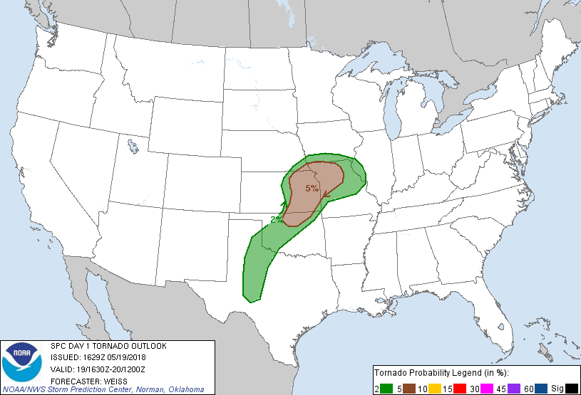
Probability of a tornado within 25 miles of a point. Hatched Area: 10% or greater probability of EF2 - EF5 tornadoes within 25 miles of a point.
Day 1 Tornado Risk
Area (sq. mi.)
Area Pop.
Some Larger Population Centers in Risk Area
5 %
57,847
4,102,113
Kansas City, MO...Wichita, KS...Overland Park, KS...Kansas City, KS...Topeka, KS...
2 %
100,609
4,932,777
Oklahoma City, OK...Tulsa, OK...Abilene, TX...Norman, OK...Lawton, OK...
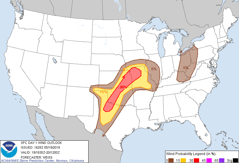
Probabilistic Damaging Wind Graphic
Probability of damaging thunderstorm winds or wind gusts of 50 knots or higher within 25 miles of a point. Hatched Area: 10% of greater probability of wind gusts 65 knots or greater within 25 miles of a point.
Day 1 Wind Risk
Area (sq. mi.)
Area Pop.
Some Larger Population Centers in Risk Area
30 %
64,741
3,964,126
Kansas City, MO...Wichita, KS...Overland Park, KS...Kansas City, KS...Topeka, KS...
15 %
136,306
5,540,055
Oklahoma City, OK...Tulsa, OK...Springfield, MO...Abilene, TX...Norman, OK...
SPC AC 191629
Day 1 Convective Outlook
NWS Storm Prediction Center Norman OK
1129 AM CDT Sat May 19 2018
Valid 191630Z - 201200Z
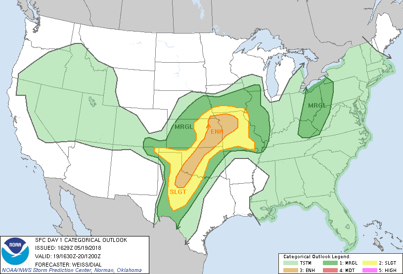
...THERE IS AN ENHANCED RISK OF SEVERE THUNDERSTORMS OVER PARTS OF
THE SOUTHERN AND CENTRAL PLAINS INTO THE LOWER MISSOURI VALLEY....
...SUMMARY...
Severe thunderstorms will develop across the central and southern
Plains into the lower Missouri Valley this afternoon and evening.
Very large hail and damaging winds are the primary threats. A few
strong storms are also possible from eastern Ohio and Kentucky into
western Pennsylvania and West Virginia.
...Central and Southern Plains into the Lower Missouri Valley...
The large scale pattern is characterized by southwesterly winds in
the mid-upper levels to the south of a weak upper low over the
central Plains. The low is forecast to move toward the east and
slowly weaken through tonight as several weak perturbations embedded
in the flow progress east-northeastward from the central/southern
High Plains toward the lower Missouri Valley.
A complicated convective scenario is expected this period as active
nocturnal storms moved across Kansas in particular, and with ongoing
convection continuing from southeast Kansas into southern Missouri.
The storms have generated a composite outflow boundary from
southwest Missouri across northern Oklahoma, and the evolution of
this boundary will likely have an impact on the intensity and mode
of subsequent convective development along/north of the boundary
this afternoon. To the northwest of this boundary, a cold front is
expected to move southeast across the region, preceded by a gravity
wave/bore-like feature seen in satellite imagery moving across
central Kansas. Over the southern High Plains a dry line is
expected to mix eastward over west Texas.
Visible imagery shows limited clouds over Oklahoma and west Texas,
with diminishing clouds spreading from central into eastern Kansas
in the wake of earlier convection. 12Z soundings show steep
mid-level lapse rates present from west Texas and Oklahoma into
western and central parts of Kansas, and this plume is expected to
spread into eastern Kansas in association with the deeper southwest
flow aloft. Moisture will be sufficient to develop moderate
instability in areas where strong diabatic heating occurs with
MLCAPE of 1500-2500 J/kg expected. Southwest mid-level winds of
35-45 kt will contribute to bulk shear of 40-45 kt which will
enhance storm organization and intensity including potential for a
few supercells to form.
CAM guidance suggests initial storms may develop over parts of
western/north central Oklahoma and south central Kansas by 21-22Z,
with additional storms then forming by 00Z farther north in north
central/northeast Kansas, and southward from southwest Oklahoma into
Texas. The steep lapse rates suggest potential for large hail,
including some producing significant hail during the initial phases
of storm maturation. Guidance indicates storms will grow upscale
into several bowing line segments by evening with the severe threat
transitioning to primarily a damaging wind threat. In addition,
backed surface winds with an easterly component north of the
aforementioned outflow boundary may result in stronger vertical
shear with a threat of a few tornadoes from north central Oklahoma
into parts of eastern Kansas and northwest Missouri.
.....Ohio Valley to the north-central Appalachians...
Modestly enhanced low/mid-level winds are expected across the region
to the east of an gradually weakening upstream shortwave trough.
Generally moist profiles are anticipated with the resulting modest
instability and weak mid-level lapse rates precluding robust
updrafts. Even so, a few bowing segments/stronger downdrafts capable
of locally damaging wind gusts are possible.
..Weiss/Dial.. 05/19/2018
CLICK TO GET WUUS01 PTSDY1 PRODUCT
NOTE: THE NEXT DAY 1 OUTLOOK IS SCHEDULED BY 2000Z