   ZCZC SPCPWOSPC ALL
   WOUS40 KWNS 052024
   ALZ000-ARZ000-LAZ000-MSZ000-TNZ000-060200-

   PUBLIC SEVERE WEATHER OUTLOOK
   NWS STORM PREDICTION CENTER NORMAN OK
   0224 PM CST MON NOV 05 2018

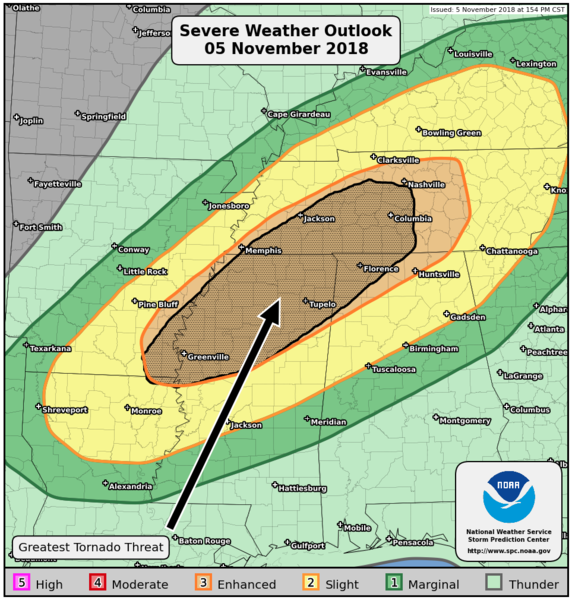
   ...Severe thunderstorms expected over parts of the ArkLaMiss to the
   Tennessee Valley this evening and overnight...

   * LOCATIONS...
     Northern Mississippi
     Western and Middle Tennessee
     Northwestern Alabama
     Southeastern Arkansas
     Northeastern Louisiana

   * HAZARDS...
     A few intense tornadoes
     Scattered damaging winds

   * SUMMARY...
     Severe storms capable of damaging winds and tornadoes are likely
     this evening and overnight across the ArkLaMiss region and
     Tennessee Valley. The severe threat is expected to begin near or
     just after sunset near the Mississippi River and continue
     through the overnight hours into the Tennessee Valley.

   Preparedness actions...

   Tornadoes at night can be particularly dangerous because they
   are usually fast-moving and difficult to see. Stay tuned to
   NOAA Weather Radio, weather.gov, or other media for watches and
   warnings. A tornado watch means that conditions are favorable
   for tornadoes to form during the next several hours. If a tornado
   warning is issued for your area, move to a place of safety,
   ideally in a basement or interior room on the lowest floor of a
   sturdy building.

   &&

   ..Thompson.. 11/05/2018

   $$
|
