Oklahoma City, OK...Tampa, FL...St. Petersburg, FL...Tallahassee, FL...Gainesville, FL...
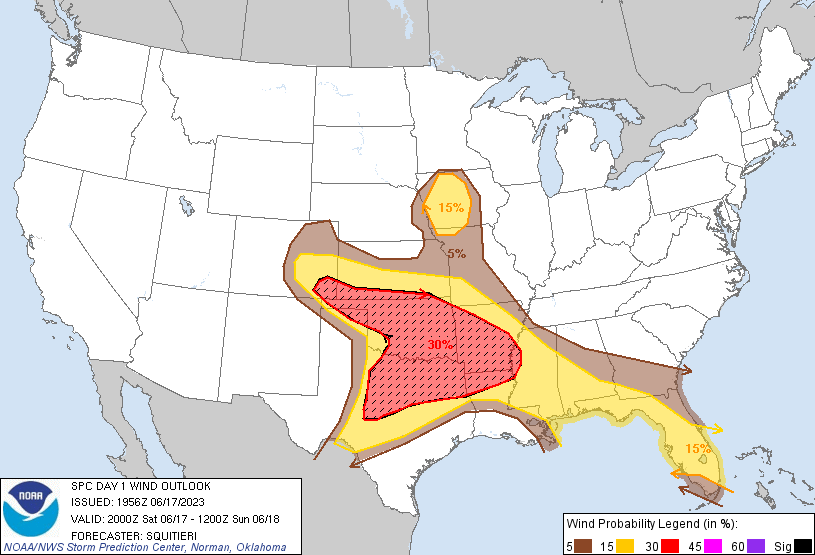
Probabilistic Damaging Wind Graphic
Probability of damaging thunderstorm winds or wind gusts of 50 knots or higher within 25 miles of a point. Hatched Area: 10% of greater probability of wind gusts 65 knots or greater within 25 miles of a point.
Day 1 Wind Risk
Area (sq. mi.)
Area Pop.
Some Larger Population Centers in Risk Area
SIG SEVERE
191,499
15,418,975
Dallas, TX...Fort Worth, TX...Oklahoma City, OK...Tulsa, OK...Arlington, TX...
30 %
189,251
15,325,670
Dallas, TX...Fort Worth, TX...Oklahoma City, OK...Tulsa, OK...Arlington, TX...
15 %
285,530
28,170,494
Austin, TX...Miami, FL...Colorado Springs, CO...Wichita, KS...Tampa, FL...
5 %
214,571
19,993,680
San Antonio, TX...Jacksonville, FL...Memphis, TN...Denver, CO...Kansas City, MO...
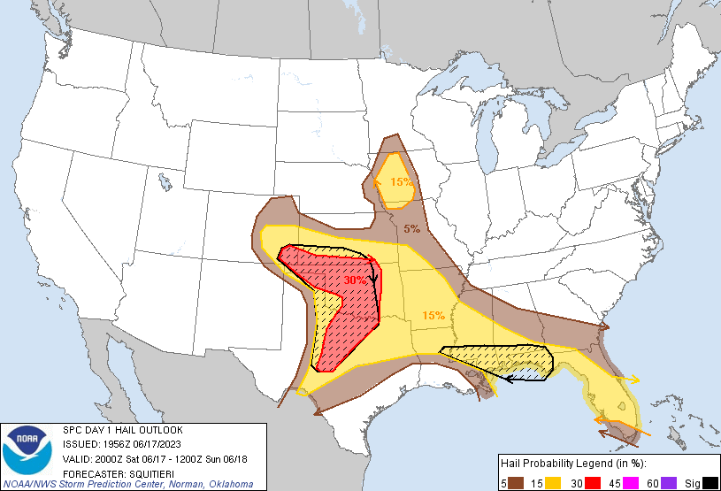
Probabilistic Large Hail Graphic
Probability of hail 1" or larger within 25 miles of a point. Hatched Area: 10% or greater probability of hail 2" or larger within 25 miles of a point.
Day 1 Hail Risk
Area (sq. mi.)
Area Pop.
Some Larger Population Centers in Risk Area
SIG SEVERE
155,777
8,365,652
Fort Worth, TX...Oklahoma City, OK...Mobile, AL...Abilene, TX...Norman, OK...
30 %
96,031
5,335,312
Fort Worth, TX...Oklahoma City, OK...Tulsa, OK...Abilene, TX...Norman, OK...
15 %
347,745
34,651,262
Dallas, TX...Miami, FL...Colorado Springs, CO...Arlington, TX...Wichita, KS...
5 %
253,178
23,673,024
San Antonio, TX...Jacksonville, FL...Austin, TX...Memphis, TN...Denver, CO...
SPC AC 171956
Day 1 Convective Outlook
NWS Storm Prediction Center Norman OK
0256 PM CDT Sat Jun 17 2023
Valid 172000Z - 181200Z
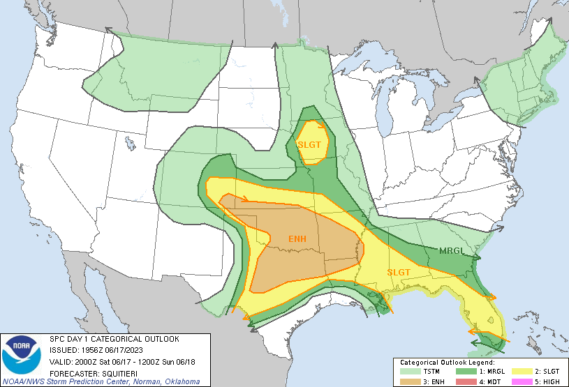
...THERE IS AN ENHANCED RISK OF SEVERE THUNDERSTORMS ACROSS PORTIONS
OF THE SOUTHERN HIGH PLAINS...EXTENDING INTO THE SOUTHERN PLAINS AND
THE LOWER MISSISSIPPI VALLEY...
...THERE IS A SLIGHT RISK OF SEVERE THUNDERSTORMS FOR PARTS OF
WESTERN INTO CENTRAL IOWA...
...SUMMARY...
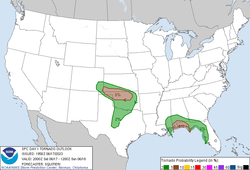
Severe thunderstorms, capable of producing damaging gusts, large
hail, or tornadoes, are possible over a vast area from Colorado to
Florida, and central Texas to the lower Missouri Valley. One or more
damaging wind swaths may occur across the southern Plains into the
lower Mississippi Valley this evening into tonight.
...20Z update...
The enhanced risk was expanded southward and eastward to cover much
of northern Texas into the lower MS Valley. An elongated
west-to-east corridor of strong to potentially extreme instability
is becoming established, from parts of western TX into MS, with the
latest mesoanalysis showing up to 5000 J/kg MLCAPE in spots, with
nearly the entire southern CONUS overspread by strong mid-level flow
and associated 50+ kts of effective bulk shear. At least one or more
MCSs are expected to develop from upscale-growing supercells and/or
multicellular clusters tonight, and rapidly propagate eastward in
the aforementioned favorable environment. Some high resolution
guidance shows one MCS traversing central/northern OK, with another
MCS moving across northern/central TX into the lower MS Valley. Any
of the MCSs that organize will have the potential to produce an
extensive swath of damaging gusts, and at least a few instances of
65+ kt gusts are possible. Still, details in MCS evolution, from
northern OK, to central TX, remains nebulous, and it is unclear
which MCS would dominate and have the potential to become
long-lived. As such, within the broader Category 3/Enhanced risk
area, there may be a gap in severe potential. Similarly, confidence
is also too low to introduce Category 4/Moderate Risk probabilities
this outlook. Nonetheless, the existence of a widespread area of
favorably overlapping strong shear/CAPE poised to experience
scattered severe storms with some upscale growth suggests that
broader Enhanced-Risk probabilities are warranted.
Significant-severe hail probabilities in the Southeast were extended
farther west into southern MS to account for the possibility of 2+
inch diameter hail occurring with ongoing supercells in
central/southern MS. Here, MRMS mosaic radar data shows MESH cores
already approaching 2 inches in spots. The rest of the outlook
remains largely on track, with only slight adjustments made to
probabilities to reflect the latest observations or guidance
consensus.
..Squitieri.. 06/17/2023
.PREV DISCUSSION... /ISSUED 1140 AM CDT Sat Jun 17 2023/
...Southeast CO to Arkansas...
Morning water vapor imagery shows a well-defined shortwave trough
over southwest CO. This feature will cross the Rockies and begin
affecting the High Plains this afternoon, promoting scattered
thunderstorms off the high terrain and foothills. Initial supercell
storms over southeast CO will be in a region of steep mid-level
lapse rates and moderate CAPE, favorable for large hail. As
activity moves/builds eastward into southwest KS, the northern TX
Panhandle, and northwest OK, it will encounter high CAPE values and
increasingly strong low-level winds. Supercells with very large
hail, significant wind damage potential, and a few tornadoes may
affect this area during the evening. Upscale growth of this cluster
of storms into a fast-moving bowing complex remains likely, with
activity moving across northern OK into northwest AR tonight.
...North TX...
A 50-60 knot westerly mid-level jet max is accompanying the
aforementioned shortwave trough over CO. This wind max will move
across the TX Panhandle this evening, with enhanced forcing for
ascent affecting the dryline over west TX. This will lead to rapid
supercell development in a very moist and unstable environment.
Very large hail and damaging winds are expected with the stronger
cells. Several CAM solutions favor splitting supercells, with
left-movers tracking northeastward toward the Red River through the
evening with a continued risk of significant severe. Therefore have
extended the ENH risk into these areas.
...MS/AL/FL...
Morning model guidance shows a subtle shortwave trough currently
over west TN tracking southeastward into AL, with an associated
40-50 knot mid-level wind max moving across MS. Strong daytime
heating of a very moist boundary layer ahead of these features
should result in scattered severe thunderstorm development by mid
afternoon over parts of southeast MS, southern AL, and the FL
Panhandle. Given the strength of the deep-layer shear, supercell
structures capable of large hail and damaging winds are expected. A
tornado or two is also possible as the storms approach the coast
late this afternoon. Activity should move offshore after dark.
...Western IA...
A well-defined remnant MCV is noted this morning over
central/eastern NE. Southerly low-level winds ahead of this
circulation will maintain near 70F dewpoints over western IA, where
strong heating is occurring. This should lead to scattered
afternoon thunderstorms. Forecast soundings show sufficient
vertical shear for organized multicell or occasional supercell
storms capable of hail and damaging winds. Therefore have added a
SLGT risk to this region for this afternoon and early evening.
CLICK TO GET WUUS01 PTSDY1 PRODUCT
NOTE: THE NEXT DAY 1 OUTLOOK IS SCHEDULED BY 0100Z