|
| Public Severe Weather Outlook (PWO) |
|
Print Version
|
Note: During early morning hours (approximately 6am Central time), the SPC will produce a multimedia briefing MP4 file shortly after the PWO issuance. Please check back momentarily for a link to this MP4 file on this page. Please note the briefing may be out of date 5 hours after its issuance and there will be no subsequent updates during the day. Please send comments or questions to spc.feedback@noaa.gov or via the feedback page.
View What is a Watch? clip.
|

|
   ZCZC SPCPWOSPC ALL
   WOUS40 KWNS 081334
   ALZ000-FLZ000-LAZ000-MSZ000-TXZ000-081800-

   PUBLIC SEVERE WEATHER OUTLOOK
   NWS STORM PREDICTION CENTER NORMAN OK
   0734 AM CST MON JAN 08 2024

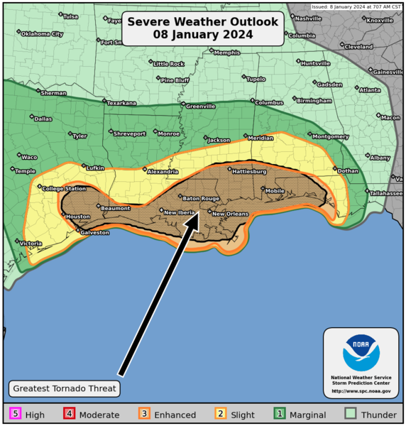
   ...Severe thunderstorms expected over parts of the Gulf Coast later
   today and tonight...

   * LOCATIONS...
     Southern Louisiana
     Southern Mississippi
     Southeast Texas
     Southern Alabama
     Florida Panhandle

   * HAZARDS...
     A few intense tornadoes
     Scattered damaging winds, some hurricane force
     Isolated large hail

   * SUMMARY...
     Severe thunderstorms capable of strong wind gusts and tornadoes
     are expected across the Gulf Coast States this afternoon through
     early Tuesday morning. This includes the possibility of strong
     tornadoes and a significant nighttime severe weather risk for
     southeast Louisiana and southern Mississippi into southern
     Alabama and the western Florida Panhandle.

   Preparedness actions...

   Tornadoes at night can be particularly dangerous because they
   are usually fast-moving and difficult to see. Stay tuned to
   NOAA Weather Radio, weather.gov, or other media for watches and
   warnings. A tornado watch means that conditions are favorable
   for tornadoes to form during the next several hours. If a tornado
   warning is issued for your area, move to a place of safety,
   ideally in a basement or interior room on the lowest floor of a
   sturdy building.

   &&

   ..Guyer.. 01/08/2024

   $$
|
|
Top of Page/All Outlooks/Home
|
| Retrieving Previous PWOs |
|---|
|
|
|


