|
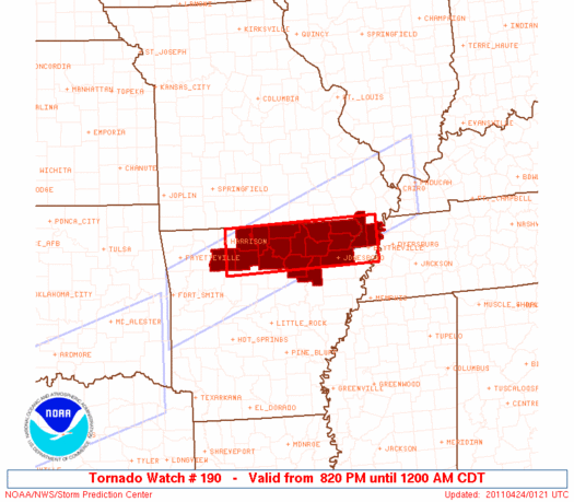
Initial List of Counties in SPC Tornado Watch 190 (WOU)
|
Back to Watch 190
|
 |
   WOUS64 KWNS 240116
   WOU0

   BULLETIN - IMMEDIATE BROADCAST REQUESTED
   TORNADO WATCH OUTLINE UPDATE FOR WT 190
   NWS STORM PREDICTION CENTER NORMAN OK
   820 PM CDT SAT APR 23 2011

   TORNADO WATCH 190 IS IN EFFECT UNTIL 1200 AM CDT FOR THE
    FOLLOWING LOCATIONS

   ARC005-021-031-049-055-063-065-067-075-089-101-121-129-135-137-
   240500-
   /O.NEW.KWNS.TO.A.0190.110424T0120Z-110424T0500Z/

   AR
   .    ARKANSAS COUNTIES INCLUDED ARE

   BAXTER               CLAY                CRAIGHEAD
   FULTON               GREENE              INDEPENDENCE
   IZARD                JACKSON             LAWRENCE
   MARION               NEWTON              RANDOLPH
   SEARCY               SHARP               STONE


   MOC069-155-240500-
   /O.NEW.KWNS.TO.A.0190.110424T0120Z-110424T0500Z/

   MO
   .    MISSOURI COUNTIES INCLUDED ARE

   DUNKLIN              PEMISCOT


   ATTN...WFO...LZK...MEG...
|
| Aviation Watch (SAW) for WW190 |
|---|
 |
| Note:
The Aviation Watch (SAW) product is an approximation to the watch area.
The actual watch is depicted by the shaded areas. |
   SAW0
   WW 190 TORNADO AR MO 240120Z - 240500Z
   AXIS..30 STATUTE MILES NORTH AND SOUTH OF LINE..
   15S HRO/HARRISON AR/ - 55ENE JBR/JONESBORO AR/
   ..AVIATION COORDS.. 25NM N/S /48ESE RZC - 21WNW DYR/
   HAIL SURFACE AND ALOFT..2.5 INCHES. WIND GUSTS..60 KNOTS.
   MAX TOPS TO 500. MEAN STORM MOTION VECTOR 27030.

   LAT...LON 36499315 36568973 35708973 35619315

   THIS IS AN APPROXIMATION TO THE WATCH AREA.  FOR A
   COMPLETE DEPICTION OF THE WATCH SEE WOUS64 KWNS
   FOR WOU0.
|
|


 @NWSSPC
