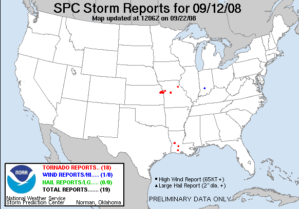
20080912's Storm Report (1200 UTC - 1159 UTC)
|
< 080911 Reports
080913 Reports >
|
|
| Note: All data are considered preliminary |
| Tornado Reports (in CSV format) |
|---|
Time | | Location | County | State | Lat | Lon | Comments |
| 2130 | | MAMOU | EVANGELINE | LA | 3063 | 9242 | LAW ENFORCEMENT REPORTED A TORNADO IN MAMOU NEAR FRED ST AND HWY 95 WITH DAMAGE TO 10-15 HOMES. (LCH) |
| 2133 | | 3 W BALDWIN CITY | DOUGLAS | KS | 3878 | 9524 | EMERGENCY MANAGER RELAYED REPORT FROM PUBLIC OF BRIEF TOUCHDOWN AT 1365 N 300 RD. (TOP) |
| 2138 | | 3 W BALDWIN CITY | DOUGLAS | KS | 3878 | 9524 | EMERGENCY MANAGER RELAYED REPORT FROM PUBLIC OF BRIEF TOUCHDOWN AT 1365 N 300 RD. (TOP) |
| 2138 | | 6 N BALDWIN CITY | DOUGLAS | KS | 3886 | 9518 | BRIEF TOUCHDOWN REPORTED AT 98E 1550 RD. (TOP) |
| 2141 | | 2 N GUEYDAN | VERMILION | LA | 3006 | 9251 | POSSIBLE TORNADO REPORTED NEAR GUEYDAN. (LCH) |
| 2154 | | 7 NE BALDWIN CITY | DOUGLAS | KS | 3885 | 9509 | TORNADO AND DEBRIS IN THE AIR SPOTTED BY DEPUTY AT 1061 N 900 RD. (TOP) |
| 2206 | | 4 SW LACAMP | VERNON | LA | 3113 | 9297 | POSSIBLE TORNADO REPORTED BY AMATEUR RADIO (LCH) |
| 2210 | | 3 SE SLAGLE | VERNON | LA | 3117 | 9309 | HAM RADIO OPERATORS REPORTED A TORNADO NEAR SLAGLE. (LCH) |
| 2210 | | 2 N SPRING HILL | JOHNSON | KS | 3878 | 9483 | BRIEF TOUCHDOWN WITH DEBRIS WHIRL (EAX) |
| 2213 | | 3 SW DE SOTO | JOHNSON | KS | 3894 | 9499 | TORNADO REPORTED NEAR 103RD AND SUNFLOWER IN CLEARVIEW CITY. (EAX) |
| 2225 | | 2 E DE SOTO | JOHNSON | KS | 3897 | 9491 | RELAYED FROM WFO TOP FROM KANSAS STATE TROOPER AT 83RD AND CEDAR CREEK. (EAX) |
| 2229 | | 2 SW BONNER SPRINGS | WYANDOTTE | KS | 3903 | 9491 | BREIF TOUCHDOWN (EAX) |
| 2240 | | 3 N SEDALIA | PETTIS | MO | 3875 | 9323 | CONFIRMED TOUCHDOWN WITH STRUCTURE DAMAGE (EAX) |
| 2244 | | 3 E HUGHESVILLE | PETTIS | MO | 3884 | 9324 | CONFIRMED TOUCHDOWN WITH STRUCTURE DAMAGE NEAR TEH INTERSECTION OF HIGHWAY 65 AND COUNTY ROADS J AND D. (EAX) |
| 2253 | | 4 SE OVERLAND PARK | JOHNSON | KS | 3887 | 9463 | BRIEF TOUCHDOWN (EAX) |
| 2336 | | 4 SE INDEPENDENCE | JACKSON | MO | 3905 | 9430 | BRIEF TOUCHDOWN NEAR I-70 AND M-291 INTERSECTION (EAX) |
| 2336 | | 1 SE INDEPENDENCE | MONROE | MO | 3958 | 9176 | BRIEF TOUCHDOWN JUST NW OF I-70 AND M-291 INTERSECTION (EAX) |
| 0015 | | 1 E MAMOU | EVANGELINE | LA | 3063 | 9240 | TORNADO REPORTED BY LAW ENFORCEMENT. (LCH) |
| Hail Reports (in CSV format) |
|---|
| No reports received |
| Wind Reports (in CSV format) |
|---|
Time | Speed | Location | County | State | Lat | Lon | Comments |
| 2325 | UNK | 6 NW OOLITIC | LAWRENCE | IN | 3895 | 8661 | TREES DOWN JUST NORTH OF SPRINGVILLE. TIME ESTIMATED. (IND) |
| Full report
in comma-separated values (CSV) format and in KML format.
|
| Fields marked UNK are unknown |
| All Times UTC |
| Wind Gusts in MPH |
| Hail Sizes in 1/100 of an Inch (75 = 0.75") |
| LAT/LON in decimal degrees to two decimals, see SPC FAQ for more info |
| List of Weather Forecast Office 3-letter IDs appear in the report comments section |
|
|
|
Top/Storm Reports/Home
|


 @NWSSPC