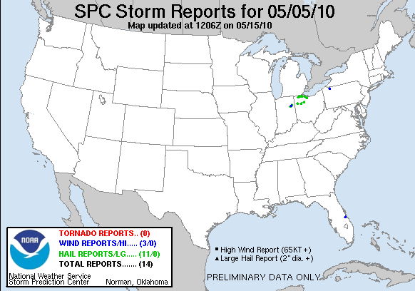
20100505's Storm Report (1200 UTC - 1159 UTC)
|
< 100504 Reports
100506 Reports >
|
|
| Note: All data are considered preliminary |
| Tornado Reports (CSV) (Raw Tornado CSV) |
|---|
| No reports received |
| Hail Reports (CSV) (Raw Hail CSV) |
|---|
Time | Size | Location | County | State | Lat | Lon | Comments |
| 2202 | 150 | WARREN | HUNTINGTON | IN | 4068 | 8543 | (IWX) |
| 2212 | 100 | 18 NE TIFFIN | SANDUSKY | OH | 4130 | 8293 | (CLE) |
| 2220 | 175 | BLUFFTON | WELLS | IN | 4074 | 8517 | HAIL RANGED IN SIZE FROM PEA TO GOLFBALL...TIME ESTIMATED FROM RADAR (IWX) |
| 2314 | 100 | DELPHOS | ALLEN | OH | 4084 | 8434 | (IWX) |
| 2347 | 100 | 1 NE ADA | HARDIN | OH | 4078 | 8381 | (ILN) |
| 2356 | 175 | 1 S WAUSEON | FULTON | OH | 4153 | 8414 | 1548 STATE ROAD 108 JUST SOUTH OF WAUSEON (IWX) |
| 0005 | 100 | SWANTON | FULTON | OH | 4159 | 8389 | (IWX) |
| 0010 | 100 | WHARTON | WYANDOT | OH | 4086 | 8346 | PENNY WITH A FEW QUARTER SIZE HAIL. (CLE) |
| 0015 | 125 | MAUMEE | LUCAS | OH | 4157 | 8365 | (CLE) |
| 0020 | 175 | PERRYSBURG | WOOD | OH | 4155 | 8362 | (CLE) |
| 0040 | 100 | OAK HARBOR | OTTAWA | OH | 4151 | 8315 | NICKEL WITH SOME QUARTER SIZE HAIL. HAIL LASTED 3 MINUTES. (CLE) |
| Wind Reports (CSV) (Raw Wind CSV) |
|---|
Time | Speed | Location | County | State | Lat | Lon | Comments |
| 2015 | UNK | 4 S PALM BAY | BREVARD | FL | 2792 | 8067 | ALUMINUM CARPORT BLOWN ACROSS ROAD AT FEARS RD SE AND SAN FILLIPPO DRIVE. (MLB) |
| 2211 | UNK | LIBERTY CENTER | WELLS | IN | 4070 | 8528 | PORCH WINDOW BLOWN OUT...HAIL OF UNKNOWN SIZE COVERED THE GROUND (IWX) |
| 0140 | UNK | 10 N TIDIOUTE | WARREN | PA | 4183 | 7940 | TREES AND WIRES DOWN. (CTP) |
| Full report
in comma-separated values (CSV) format and in KML format.
|
| Raw full report
in comma-separated values (CSV) format |
| Fields marked UNK are unknown |
| All Times UTC |
| Wind Gusts in MPH |
| Hail Sizes in 1/100 of an Inch (175 = 1.75") |
| LAT/LON in decimal degrees to two decimals, see SPC FAQ for more info |
| List of Weather Forecast Office 3-letter IDs appear in the report comments section |
|
|
|
Top/Storm Reports/Home
|


 @NWSSPC