|
| Mesoscale Discussion 816 |
|
< Previous MD
Next MD >
|
|
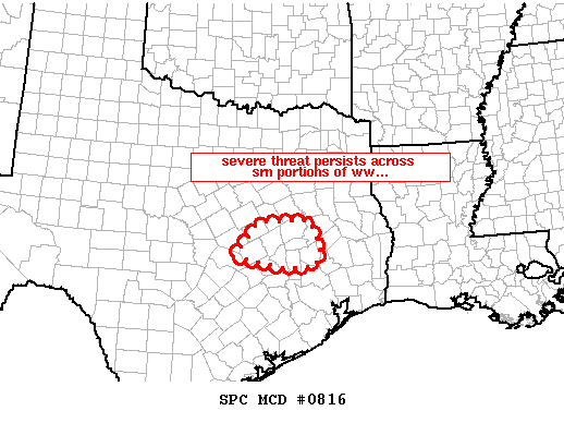
   MESOSCALE DISCUSSION 0816
   NWS STORM PREDICTION CENTER NORMAN OK
   0821 PM CDT WED MAY 07 2008

   AREAS AFFECTED...PARTS OF E CENTRAL TX

   CONCERNING...TORNADO WATCH 274...

   VALID 080121Z - 080215Z

   THE SEVERE WEATHER THREAT FOR TORNADO WATCH 274 CONTINUES.

   SEVERE/TORNADO THREAT CONTINUES ACROSS SERN PORTIONS OF WW 274.

   STORMS HAVE MOVED GENERALLY E OF WW...THOUGH A FEW CELLS PERSIST
   ACROSS SERN PORTIONS OF THE WATCH -- INCLUDING A SUPERCELL NOW
   MOVING ACROSS NRN ROBERTSON CO WHICH HAS RECENTLY PRODUCED A
   TORNADO.  THOUGH THE THREAT SHOULD CONTINUE SHIFTING SLOWLY EWD/OUT
   OF WW WITH TIME...THREAT MAY LINGER AN HOUR OR SO BEYOND 08/02Z AND
   THUS A LOCAL EXTENSION OF THE WW MAY BE REQUIRED.

   ..GOSS.. 05/08/2008


   ATTN...WFO...HGX...FWD...EWX...

   30689745 31419685 31489561 30919532 30519547 30479615
|
|
Top/All Mesoscale Discussions/Forecast Products/Home
|
|


 @NWSSPC