Skip Navigation Links weather.gov 
NOAA logo-Select to go to the NOAA homepage NOAA's National Weather Service   Select to go to the NWS homepage
Storm Prediction Center
navigation bar left  
  navigation bar end cap


USA.gov is the U.S. Government's official Web portal to all Federal, state and local government Web resources and services.

Mesoscale Discussion 978
< Previous MD          Next MD >
MD 978 graphic
   
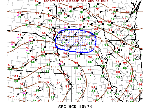
   MESOSCALE DISCUSSION 0978
   NWS STORM PREDICTION CENTER NORMAN OK
   0521 PM CDT SUN JUN 07 2009
   
   AREAS AFFECTED...IA
   
   CONCERNING...SEVERE POTENTIAL...WATCH POSSIBLE 
   
   VALID 072221Z - 072315Z
   
   LOW LEVEL WARM ADVECTION APPEARS TO BE ENHANCING ONGOING CONVECTION
   ACROSS MUCH OF CNTRL/NRN IA ATTM.  ELEVATED THUNDERSTORM POTENTIAL
   SHOULD INCREASE OVER MUCH OF THIS REGION OVER THE NEXT FEW HOURS. 
   LARGE HAIL IS THE PRIMARY SEVERE RISK AND GIVEN CURRENT TRENDS A
   SEVERE THUNDERSTORM WATCH MAY BE REQUIRED SOON.
   
   ..DARROW.. 06/07/2009
   
   
   ATTN...WFO...ARX...DMX...FSD...OAX...
   
   LAT...LON   41829531 42219636 43309586 43409369 42899213 41739267
               41829531 
   
Top/All Mesoscale Discussions/Forecast Products/Home
Weather Topics:
Watches, Mesoscale Discussions, Outlooks, Fire Weather, All Products, Contact Us

NOAA / National Weather Service
National Centers for Environmental Prediction
Storm Prediction Center
120 David L. Boren Blvd.
Norman, OK 73072 U.S.A.
spc.feedback@noaa.gov
Page last modified: January 01, 1970
Disclaimer
Information Quality
Help
Glossary
Privacy Policy
Freedom of Information Act (FOIA)
About Us
Career Opportunities