|
| Mesoscale Discussion 2303 |
|
< Previous MD Next MD >
|
|
MESOSCALE DISCUSSION 2303
NWS STORM PREDICTION CENTER NORMAN OK
0144 PM CST TUE NOV 08 2011
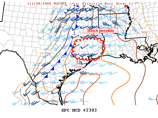
AREAS AFFECTED...SERN TX
CONCERNING...SEVERE POTENTIAL...WATCH POSSIBLE
VALID 081944Z - 082045Z
A TORNADO WATCH MAY BE ISSUED FOR PORTIONS OF SERN TX SHORTLY.
ALTHOUGH THE STRONGEST FORCING IS LIFTING NORTH OF SERN TX...
APPROACHING COLD FRONT SHOULD AID IN STORM COVERAGE INCREASING
THROUGH THE AFTERNOON. MUCAPES BETWEEN 2000-3000 J/KG COMBINED WITH
DEEP LAYER SHEAR AT 40-50 KT AND 1 KM SRH BETWEEN 200-250 M2/S2
WOULD SUPPORT AN ISOLATED TORNADO THREAT. HOWEVER...THE QUESTION IS
WITH THE LACK OF LARGER SCALE FORCING WILL THE SEVERE STORM COVERAGE
BE SUFFICIENT FOR A WATCH. DISCUSSIONS WITH THE HOUSTON AND LAKE
CHARLES NWS OFFICES WILL BE FORTHCOMING.
..IMY.. 11/08/2011
ATTN...WFO...LCH...SHV...HGX...
LAT...LON 30899607 31089497 31059393 30819370 30099369 29589421
29549508 29749634 30379628 30899607
|
|
Top/All Mesoscale Discussions/Forecast Products/Home
|
|


 @NWSSPC