Skip Navigation Links weather.gov 
NOAA logo-Select to go to the NOAA homepage NOAA's National Weather Service   Select to go to the NWS homepage
Storm Prediction Center
navigation bar left  
  navigation bar end cap


USA.gov is the U.S. Government's official Web portal to all Federal, state and local government Web resources and services.

Mesoscale Discussion 1967
< Previous MD         Next MD >
MD 1967 graphic
   
   MESOSCALE DISCUSSION 1967
   NWS STORM PREDICTION CENTER NORMAN OK
   0226 PM CDT TUE SEP 18 2012
   
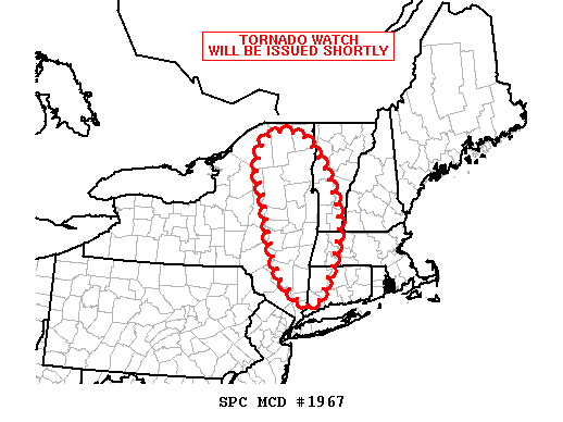
   AREAS AFFECTED...ERN NY...PARTS OF WRN/SRN VT...WRN MA...WRN CT
   
   CONCERNING...SEVERE POTENTIAL...WATCH NEEDED SOON 
   
   VALID 181926Z - 182000Z
   
   PROBABILITY OF WATCH ISSUANCE...95 PERCENT
   
   SUMMARY...A TORNADO WATCH WILL BE ISSUED SHORTLY.
   
   DISCUSSION...WEAK DESTABILIZATION AMIDST VERY STRONG
   LOW-LEVEL/DEEP-LAYER SHEAR WILL SUPPORT QLCS STRUCTURES WITH A
   THREAT FOR DMGG WINDS AND TORNADOES INTO THE EVENING HOURS. A
   TORNADO WATCH WILL BE ISSUED SHORTLY.
   
   ..COHEN/MEAD.. 09/18/2012
   
   
   ATTN...WFO...BOX...BTV...OKX...ALY...BGM...
   
   LAT...LON   41247354 41777427 42557460 43357476 44087501 44727474
               44827419 44667360 43907296 42817268 41577310 41247354 
   
Top/All Mesoscale Discussions/Forecast Products/Home
Weather Topics:
Watches, Mesoscale Discussions, Outlooks, Fire Weather, All Products, Contact Us

NOAA / National Weather Service
National Centers for Environmental Prediction
Storm Prediction Center
120 David L. Boren Blvd.
Norman, OK 73072 U.S.A.
spc.feedback@noaa.gov
Page last modified: January 01, 1970
Disclaimer
Information Quality
Help
Glossary
Privacy Policy
Freedom of Information Act (FOIA)
About Us
Career Opportunities