|
| Mesoscale Discussion 240 |
|
< Previous MD Next MD >
|
|
Mesoscale Discussion 0240
NWS Storm Prediction Center Norman OK
0844 AM CST Wed Mar 01 2017
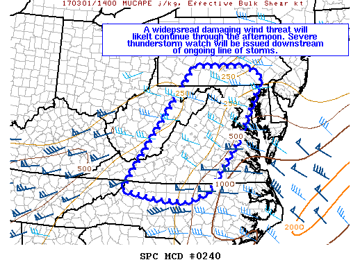
Areas affected...South-central PA...MD...DC...VA...and northwestern
NC
Concerning...Severe potential...Severe Thunderstorm Watch likely
Valid 011444Z - 011615Z
Probability of Watch Issuance...95 percent
SUMMARY...A widespread damaging wind threat will likely continue
through the afternoon. Severe thunderstorm watch downstream of
ongoing line of thunderstorms will very likely be issued by 1530Z.
DISCUSSION...A line of strong to severe thunderstorms is advancing
quickly eastward across the central Appalachians this morning.
Damaging winds will remain the main threat with this convection
given the linear mode and strong low-level winds noted on area radar
velocity imagery. In addition, an isolated tornado may also be
possible with embedded circulations within the line. The airmass
downstream of the ongoing line is not overly unstable at the moment,
with surface temperatures still generally in the 60s and dewpoints
in the mid to upper 50s. However, some diurnal heating will likely
occur as visible satellite imagery shows clearing along/east of the
Appalachians, which should support sufficient instability to
continue the damaging wind threat. Instability is more limited with
northward extent into PA, and some uncertainty does exist concerning
the potential for surface-based convection and the damaging wind
threat there.
..Gleason/Hart.. 03/01/2017
ATTN...WFO...PHI...AKQ...CTP...LWX...RAH...RNK...PBZ...RLX...
MRX...
LAT...LON 40337888 40317679 40007606 38027708 36287838 35977923
36088048 36338174 40337888
|
|
Top/All Mesoscale Discussions/Forecast Products/Home
|
|


 @NWSSPC