|
| Mesoscale Discussion 197 |
|
< Previous MD Next MD >
|
|
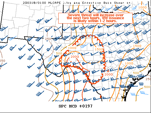
   Mesoscale Discussion 0197
   NWS Storm Prediction Center Norman OK
   0845 PM CDT Wed Mar 18 2020

   Areas affected...Texas Big Bend into the Hill Country and Edwards
   Plateau

   Concerning...Severe potential...Watch likely

   Valid 190145Z - 190245Z

   Probability of Watch Issuance...80 percent

   SUMMARY...Convective development has occurred in the Big Bend
   vicinity. Coverage is expected to increase in the next hour or so.
   Large hail and strong/severe wind gusts will be primary threats, but
   low-level wind fields will support a tornado or two within the
   expected linear segments. A WW is likely within 1-2 hours.

   DISCUSSION...A cluster of thunderstorms has initiated within the
   Davis Mountains vicinity as stronger mid-level ascent approaches
   from the southwest. Farther southeast, isolated storm development
   has also occurred across the Mexican border from Del Rio. With time,
   an increase in low-level moisture is expected to occur in
   conjunction with the deepening surface low in eastern Colorado and a
   strong southerly 850 mb jet across the region. Stronger forcing for
   ascent should lead to greater storm coverage near and northeast of
   the Big Bend with more isolated activity farther southeast.
   Northeast extent of the severe threat is also somewhat in question
   as convection has impacted areas from around the San Angelo to
   Wichita Falls vicinity.

   Regional 00Z RAOBs indicated mid-level lapse rates of 7-7.5 C/km.
   With 50-60 kts of effective bulk shear objectively analyzed,
   organized storms will be capable of large hail and isolated
   strong/severe wind gusts. Strong low-level wind fields will mean a
   tornado or two are possible with any mesovorticies that develop
   within the linear segments. A WW is likely in the next hour or two.

   ..Wendt/Hart.. 03/19/2020

   ...Please see www.spc.noaa.gov for graphic product...

   ATTN...WFO...EWX...SJT...MAF...

   LAT...LON   30470304 31360200 32180111 32220005 31679942 30849922
               29749915 28909950 28580006 28430031 29050060 29640108
               29940197 29920259 29880299 30220316 30470304
|
|
Top/All Mesoscale Discussions/Forecast Products/Home
|
|


 @NWSSPC