|
| Mesoscale Discussion 334 |
|
< Previous MD Next MD >
|
|
Mesoscale Discussion 0334
NWS Storm Prediction Center Norman OK
1247 PM CDT Sat Apr 11 2020
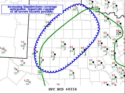
Areas affected...Permian Basin/TX South Plains into Far Northwest TX
Concerning...Severe potential...Watch likely
Valid 111747Z - 111945Z
Probability of Watch Issuance...80 percent
SUMMARY...Increasing thunderstorm coverage is anticipated over the
next few hours. Overall environment supports supercells capable of
all severe hazards and a watch will likely be needed.
DISCUSSION...GOES-16 mesosector imagery has shown numerous attempts
at deep convection across the Permian Basin and TX South Plains over
the past hour. A few of these attempts now appear successful, likely
aided by persistent low-level moisture convergence augmented by
increasing large-scale ascent. This low-level moisture convergence
and strengthening large-scale ascent is expected to continue for the
next several hours, leading to more convective initiation and
increased thunderstorm coverage.
Air mass continues to destabilize as low-level moisture advects
northward and diurnal heating intensifies. Recent surface analysis
placed 60 deg F dewpoints from SPS in far northwest TX to about 25
miles northwest of MAF in the Permian Basin. Mesoanalysis estimates
MLCAPE is already around 1500 to 2000 J/kg, with increase to around
2500 J/kg likely over the next few hours. Vertical shear is
increasing as well, creating an environment supportive of supercell
thunderstorms. Primary threat will be large to very-large hail.
Storms will likely be slightly elevated initially, but could become
surface-based with time as low-level stability erodes farther east.
Any surface-based storms would also pose a threat for damaging wind
gusts and tornadoes.
..Mosier/Grams.. 04/11/2020
...Please see www.spc.noaa.gov for graphic product...
ATTN...WFO...OUN...SJT...LUB...MAF...
LAT...LON 32630254 33810161 34530003 33279910 31590106 31580231
32630254
|
|
Top/All Mesoscale Discussions/Forecast Products/Home
|
|


 @NWSSPC