|
| Mesoscale Discussion 579 |
|
< Previous MD Next MD >
|
|
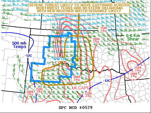
   Mesoscale Discussion 0579
   NWS Storm Prediction Center Norman OK
   0759 PM CDT Wed May 13 2020

   Areas affected...Western Oklahoma...Northwest Texas

   Concerning...Severe Thunderstorm Watch 179...

   Valid 140059Z - 140300Z

   The severe weather threat for Severe Thunderstorm Watch 179
   continues.

   SUMMARY...A severe threat is likely to continue and move eastward
   across western Oklahoma and northwest Texas this evening. Large hail
   and wind damage will be possible with the stronger cells embedded in
   a line. Weather watch issuance will likely be needed to the east of
   WW 179.

   DISCUSSION...The latest radar imagery shows a developing line
   segment from far southwest Oklahoma extending southwestward to near
   the Lubbock vicinity. This line is located along a
   northeast-to-southwest corridor of enhanced low-level convergence. A
   thermal axis is present directly south of the line where
   temperatures are in the lower 90s. This has helped the line to
   intensify over the last hour. The line will move eastward across
   western Oklahoma and northwest Texas where surface dewpoints are in
   the mid to upper 60s. The RAP is analyzing moderate to strong
   instability (MLCAPE 3000 to 3500 J/kg) with 0-6 km shear of 30 to 40
   kt. In response, the line should continue to maintain intensity and
   have a severe threat. The instability along with mid-level lapse
   rates in excess of 8.0 C/km will be favorable for large hail. A wind
   damage threat will also be likely along the more organized parts of
   the line segment. As the severe threat moves toward the edge of WW
   179, a new weather watch will likely be needed.

   ..Broyles.. 05/14/2020

   ...Please see www.spc.noaa.gov for graphic product...

   ATTN...WFO...OUN...DDC...SJT...LUB...AMA...MAF...

   LAT...LON   33500308 33910283 34610216 35200155 36010129 36550116
               36880087 36990054 37040002 36949967 36769936 36639925
               36299898 35729877 35039868 34369884 33879917 33109976
               32600067 32580083 32540182 32570269 32690302 32940309
               33500308
|
|
Top/All Mesoscale Discussions/Forecast Products/Home
|
|


 @NWSSPC