|
| Mesoscale Discussion 691 |
|
< Previous MD Next MD >
|
|
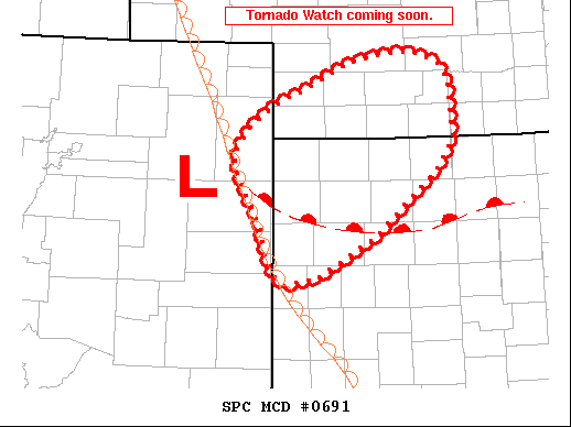
   Mesoscale Discussion 0691
   NWS Storm Prediction Center Norman OK
   0535 PM CDT Sat May 23 2020

   Areas affected...NE Colorado SW NE and NW KS

   Concerning...Severe potential...Tornado Watch likely

   Valid 232235Z - 232330Z

   Probability of Watch Issuance...95 percent

   SUMMARY...Thunderstorm are developing off the dryline in NE CO and
   NW KS. A few tornadoes will be possible with supercells through this
   evening. A tornado watch will be issued soon.

   DISCUSSION...A meso low over northeastern Colorado has backed
   low-level winds over the last several hours. Moist upslope flow is
   helping to initiate thunderstorms along the dryline west of
   Goodland. Favorable vertical shear for supercells and tornadoes will
   likely develop this evening along a warm front/wind shift
   necessitating a tornado watch soon.

   ..Lyons/Thompson.. 05/23/2020

   ...Please see www.spc.noaa.gov for graphic product...

   ATTN...WFO...GID...LBF...GLD...

   LAT...LON   38500188 38600202 38780212 38990217 39260227 39450241
               39700252 39850253 40140231 40380194 40520156 40790100
               40890050 40900013 40779978 40599965 39989960 39639985
               39510001 38990065 38570142 38500188
|
|
Top/All Mesoscale Discussions/Forecast Products/Home
|
|


 @NWSSPC