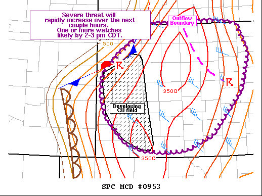
   Mesoscale Discussion 0953
   NWS Storm Prediction Center Norman OK
   0115 PM CDT Sun Jun 21 2020

   Areas affected...Portions of western and central KS

   Concerning...Severe potential...Watch likely

   Valid 211815Z - 212015Z

   Probability of Watch Issuance...95 percent

   SUMMARY...The severe threat will increase rapidly across parts of
   western into central KS over the next couple of hours. One or more
   watches will be needed by 2-3 pm CDT. Large to very large hail,
   widespread damaging winds, and a tornado are all possible.

   DISCUSSION...A very moist and unstable airmass is evolving early
   this afternoon across parts of western into central KS ahead of
   dryline and surface front. A couple of updrafts have already been
   noted along the boundary in Wallace County in northwest KS. To the
   east across north-central KS, strong to occasionally severe storms
   have continues through the morning and into this afternoon in a
   low-level confluence zone. Additional CU development has been noted
   along the associated outflow boundary. As inhibition continues to
   erode, additional thunderstorm development could zipper westward
   along that boundary over the next couple of hours. Forecast guidance
   has done a poor job of handling these storms, CAMs included, and
   some uncertainty exists with regards to convective evolution across
   that area.

   To the southwest, moisture continues to increase, with widespread
   upper 60s to low 70s F noted in 17z obs. While a broader CU field
   has yet to develop across western KS, there are some signs of
   weakening inhibition and increasing ascent spreading over the region
   via increasing mid/upper level cloudiness streaming eastward from CO
   and modified forecast soundings showing a nearly-uncapped
   environment in the next hour. As such, storms are expected to become
   more widespread in the next 1-2 hours near the surface
   boundary/dryline across western KS. MLCAPE greater than 3000 J/kg in
   the presence of 30-45 kt effective shear will result in robust,
   organized updrafts and supercell structures. A plume of very steep
   midlevel lapse rates around 8 C/km and lengthened hodographs above
   700 mb will support large to very large hail. Additionally, steep
   low level lapse rates and modest low level shear will support strong
   downdrafts and damaging winds. While convection may initially be
   semi-discrete, upward development into one or more bowing segments
   is expected as storm outflows/mergers occur in conjunction with cold
   pool development by late afternoon. While storm bases will be a bit
   high, mean mixing ratios around 14-15 g/kg and increasing effective
   SRH values across southwest KS could support a tornado or two in any
   more discrete storms.

   ..Leitman/Guyer.. 06/21/2020

   ...Please see www.spc.noaa.gov for graphic product...

   ATTN...WFO...TOP...ICT...GID...DDC...GLD...

   LAT...LON   39330134 39740076 39990040 40009971 40039867 39959796
               39309767 38499789 37499876 37169950 37120014 37190073
               37360119 37890170 38390186 38890182 39330134
|


 @NWSSPC