|
| Mesoscale Discussion 564 |
|
< Previous MD Next MD >
|
|
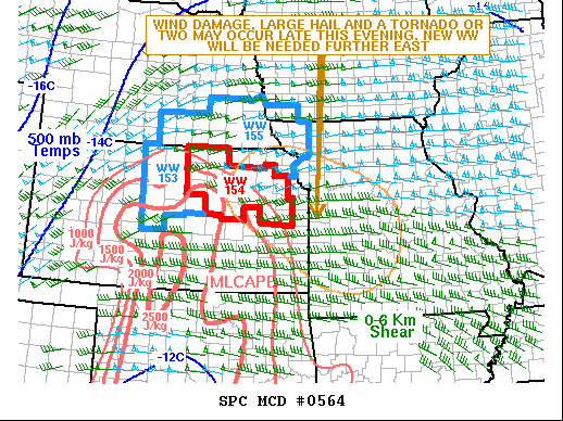
   Mesoscale Discussion 0564
   NWS Storm Prediction Center Norman OK
   0915 PM CDT Sat May 08 2021

   Areas affected...Northeast Kansas...Missouri

   Concerning...Tornado Watch 154...

   Valid 090215Z - 090415Z

   The severe weather threat for Tornado Watch 154 continues.

   SUMMARY...A wind damage, large hail and tornado threat will continue
   late this evening, affecting northeast Kansas and parts of Missouri.
   The severe threat will likely persist into the early overnight
   period necessitating a new watch further to the east.

   DISCUSSION...The latest radar imagery shows a cluster of strong to
   severe thunderstorms located from near Salina, Kansas northward into
   far southeast Nebraska. These storms are located along the northern
   edge of a moderately unstable airmass. The instability and moisture
   gradient extends east-southeastward across eastern Kansas into
   western and southern Missouri, along which a warm front is analyzed.
   Storm coverage will continue to increase with a linear MCS
   developing and moving southeastward along this gradient. As a cold
   pool organizes, supercells that remain intact as the line forms,
   will continue to have a threat for large hail and wind damage. The
   WSR-88D VWP at Topeka, Kansas shows a looped hodograph with 0-3 km
   storm relative helicity near 450 m2/s2. This will continue the
   tornado threat, especially with supercells. The wind-damage threat
   is expected to increase as the linear MCS matures, continuing after
   midnight as the line moves into western Missouri.

   ..Broyles.. 05/09/2021

   ...Please see www.spc.noaa.gov for graphic product...

   ATTN...WFO...LSX...SGF...EAX...TOP...ICT...

   LAT...LON   38699671 38069571 37449478 37079414 37009320 37499240
               38279220 39109257 39959458 39999598 39389675 38699671
|
|
Top/All Mesoscale Discussions/Forecast Products/Home
|
|


 @NWSSPC