|
| Mesoscale Discussion 1844 |
|
< Previous MD Next MD >
|
|
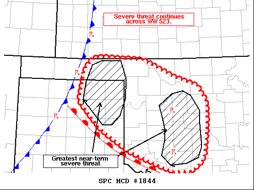
   Mesoscale Discussion 1844
   NWS Storm Prediction Center Norman OK
   0918 PM CDT Tue Oct 12 2021

   Areas affected...Western Oklahoma and the eastern Oklahoma and Texas
   Panhandles

   Concerning...Tornado Watch 523...

   Valid 130218Z - 130415Z

   The severe weather threat for Tornado Watch 523 continues.

   SUMMARY...The threat for tornadoes and severe wind continues across
   WW 523. The greatest near-term threats will reside with a pair of
   supercells across western OK, as well as intensifying storms across
   the OK/TX Panhandles.

   DISCUSSION...Vertical wind profilers from across the southern Plains
   have shown strengthening flow in the lowest 2-3 km over the past
   hour as the surface low across the southern/central High Plains
   continues to deepen and the main synoptic wave ejects into the
   Plains. This has boosted effective SRH to around 400 m2/s2 across
   much of WW 523, and aided in the organization and longevity of a
   pair of tornadic supercells across western OK. These two cells will
   continue to pose a tornado threat for the next 1-2 hours, but the
   longevity of the threat is uncertain due to a less favorable
   thermodynamic environment with eastern extent. Additional discrete
   cells ahead of the approaching cold front remain possible, but
   appears unlikely given recent failed attempts at initiation near
   Woodward, OK.

   To the west, convection along the Pacific cold front is intensifying
   as the front encounters a more unstable air mass. Severe winds have
   already been reported with this line across the Panhandles, and will
   continue to be possible as convection continues to intensify over
   the coming hours. Given the strongly sheared environment ahead of
   this line, QLCS tornadoes will also be possible - especially in the
   vicinity of any northwest to southeast surges where line-normal 0-3
   km bulk shear values will be maximized to near 40-45 knots.

   ..Moore.. 10/13/2021

   ...Please see www.spc.noaa.gov for graphic product...

   ATTN...WFO...OUN...DDC...AMA...

   LAT...LON   34889988 35380065 35990127 36740115 37040086 36989947
               36579857 36369791 35989767 35569766 35179770 34699778
               34409809 34409867 34889988
|
|
Top/All Mesoscale Discussions/Forecast Products/Home
|
|


 @NWSSPC