|
| Mesoscale Discussion 1156 |
|
< Previous MD Next MD >
|
|
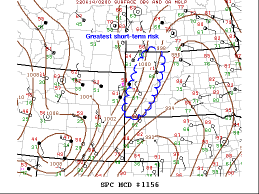
   Mesoscale Discussion 1156
   NWS Storm Prediction Center Norman OK
   0956 PM CDT Mon Jun 13 2022

   Areas affected...Western SD

   Concerning...Severe Thunderstorm Watch 360...

   Valid 140256Z - 140500Z

   The severe weather threat for Severe Thunderstorm Watch 360
   continues.

   SUMMARY...Isolated wind/hail threat will slowly shift east over the
   next few hours.

   DISCUSSION...Scattered high-based convection that developed over
   southeast WY has lifted north-northeast across western SD where
   low-level warm advection and buoyancy are a bit greater than across
   the higher Plains. 00z sounding from RAP was modestly unstable but
   notably capped around 1km AGL. This activity has been slow to shift
   east, possibly due to the CINH. However, heights will continue to
   fall across the northern High Plains tonight and this should nudge
   this corridor of convection northeast over the next few hours,
   possibly back into southern portions of ww358. Wind/hail remain
   possible with this activity.

   ..Darrow.. 06/14/2022

   ...Please see www.spc.noaa.gov for graphic product...

   ATTN...WFO...ABR...UNR...

   LAT...LON   43240396 45840272 45570165 43370270 43240396
|
|
Top/All Mesoscale Discussions/Forecast Products/Home
|
|


 @NWSSPC