|
| Mesoscale Discussion 762 |
|
< Previous MD Next MD >
|
|
Mesoscale Discussion 0762
NWS Storm Prediction Center Norman OK
1158 AM CDT Thu May 11 2023
Areas affected...much of western Kansas and small parts of bordering
states
Concerning...Severe potential...Watch likely
Valid 111658Z - 111930Z
Probability of Watch Issuance...95 percent
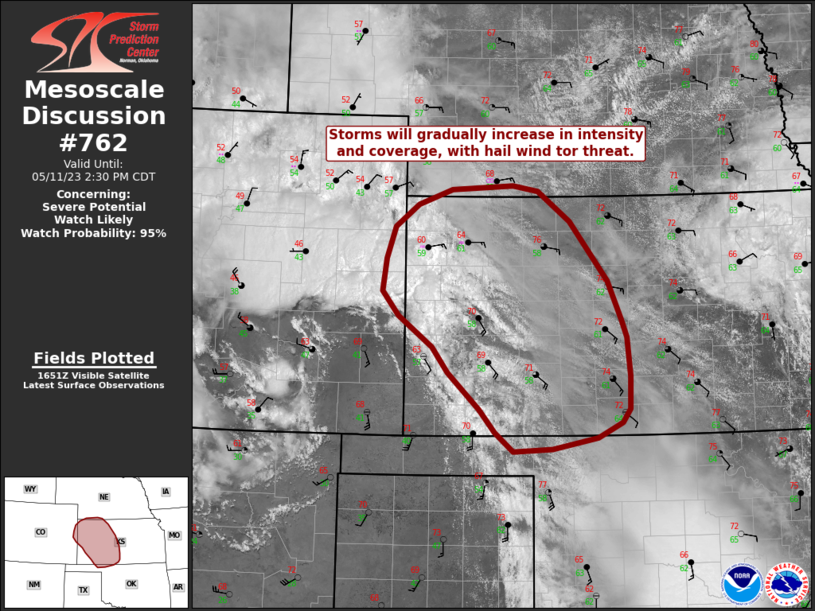
SUMMARY...Storms will gradually increase in intensity and coverage
throughout the day from eastern Colorado arcing southeastward across
western and central Kansas. Large hail is likely, with a few
tornadoes and damaging gusts possible as well.
DISCUSSION...Visible imagery show favorable boundary layer
conditioning as storms from eastern CO into western KS begin to
intensity. Surface heating will continue to steepen lapse rates and
increase instability over a wide area, from NE southward across KS.
Meanwhile, low-level winds are strengthening across the TX/OK
Panhandles into southwest KS, which will enhance convergence and
instability into southwest KS soon.
Deep-layer easterlies within the lowest 2-3 km with strengthening
southwesterlies aloft will favor supercells. While low-level SRH may
not be particularly strong due to the entrenched easterlies in the
low levels, it will be sufficient given cooling aloft and favorable
time of day. In addition, these hodographs should strongly favor
damaging hail with forward-tilting storms.
..Jewell/Guyer.. 05/11/2023
...Please see www.spc.noaa.gov for graphic product...
ATTN...WFO...ICT...OUN...GID...DDC...GLD...AMA...PUB...
LAT...LON 37159859 36979898 36839970 36800032 37030061 37330085
37790136 38100161 38500215 38800241 39210234 39610220
39900184 40080130 40140031 40069991 39699940 38939880
38449858 38239851 37739846 37339846 37159859
|
|
Top/All Mesoscale Discussions/Forecast Products/Home
|
|


 @NWSSPC