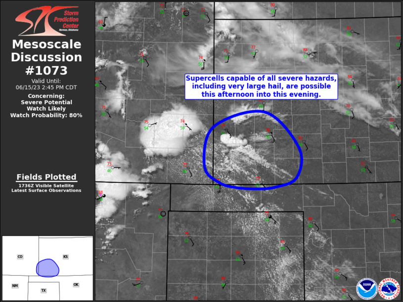
   Mesoscale Discussion 1073
   NWS Storm Prediction Center Norman OK
   1244 PM CDT Thu Jun 15 2023

   Areas affected...Southwest KS...Far Southeast CO

   Concerning...Severe potential...Watch likely

   Valid 151744Z - 151945Z

   Probability of Watch Issuance...80 percent

   SUMMARY...Supercells capable of all severe hazards, including very
   large hail, and a tornado or two are possible across far southeast
   CO into southwest KS this afternoon and evening.

   DISCUSSION...Visible satellite imagery has shown an increasingly
   agitated cumulus field across southwest KS over the past hour or so.
   A few instances of greater vertical development are now apparent
   within this field, and the expectation is for eventual thunderstorm
   initiation as air mass destabilization persists and lift, both
   attendant to the approaching shortwave trough and withing areas of
   low-level confluence, increases.

   Very steep lapse rates are in place, with mesoanalysis estimating
   8.5 to 9 deg C per km from 700 to 500 mb. Continued low-level
   moisture advection into this region is expected, counteracting any
   mixing and likely keeping dewpoints in the low 60s. This combination
   of low-level moisture and steep mid-level lapse rates will result in
   strong buoyancy, with MLCAPE around 3000 J/kg possible this
   afternoon. Vertical shear will be stronger farther south, but 30 to
   40 kt of effective bulk shear is still anticipated over this area.
   This should be sufficient for supercells, with very large hail as
   the primary risk. Some hail may exceed 2.5" in diameter. Strong
   downdrafts are possible in this region as well. There is some threat
   for a tornado or two is well, but, despite favorable low-level
   moisture, LCLs will still be relatively high. The tornado risk does
   increase with southward extent where stronger southeasterly surface
   winds are expected.

   ..Mosier/Thompson.. 06/15/2023

   ...Please see www.spc.noaa.gov for graphic product...

   ATTN...WFO...DDC...AMA...PUB...

   LAT...LON   37120013 36950062 36910101 36930150 37020189 37310224
               38030204 38310087 37650008 37120013
|


 @NWSSPC