|
| Mesoscale Discussion 1307 |
|
< Previous MD Next MD >
|
|
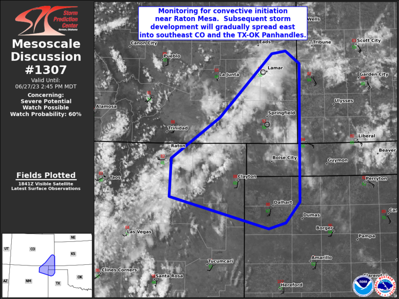
   Mesoscale Discussion 1307
   NWS Storm Prediction Center Norman OK
   0148 PM CDT Tue Jun 27 2023

   Areas affected...northeast NM...southeast CO...western OK
   Panhandle...northwest TX Panhandle

   Concerning...Severe potential...Watch possible

   Valid 271848Z - 272045Z

   Probability of Watch Issuance...60 percent

   SUMMARY...Monitoring for convective initiation near Raton Mesa.
   Subsequent storm development will gradually spread east into
   southeast CO and the TX-OK Panhandles.  The stronger storms will be
   potentially capable of peak wind gusts 60-75 mph and large hail
   diameters 1-2 inches.

   DISCUSSION...Visible satellite imagery shows a towering cumulus
   field over escarpment in northeast NM.  Surface mesoanalysis shows
   the western extension of morning thunderstorm outflow extends into
   northwest OK and southwest KS where observation sites show easterly
   component to flow.  This easterly upslope flow is resulting in upper
   60s dewpoints in Texas County, OK (middle OK Panhandle county).
   Meanwhile, strengthening southwesterly flow is overspreading the
   Sangre de Cristos early this afternoon (40-55 kt at 500 mb) on the
   southern portion of a mid-level speed max over the central Rockies.
   Deeper mixing of the boundary layer is occurring across northeast NM
   with surface winds veering to the west-southwest and dewpoints fall
   into the 30s and lower 40s near I-25.

   As the developing convection initially in a drier airmass encounters
   increasingly rich low-level moisture and a more buoyant airmass
   towards the OK/TX/CO border, expecting thunderstorms to rapidly
   intensify.  Large hail and severe gusts will be possible with the
   stronger storms.  The severe risk will increase as this activity
   approaches the longitude of the CO/KS border.

   ..Smith/Grams.. 06/27/2023

   ...Please see www.spc.noaa.gov for graphic product...

   ATTN...WFO...DDC...AMA...PUB...ABQ...

   LAT...LON   36760440 37380350 38340252 38390226 38190200 36110200
               35800227 35710259 36180444 36760440
|
|
Top/All Mesoscale Discussions/Forecast Products/Home
|
|


 @NWSSPC