|
| Mesoscale Discussion 1311 |
|
< Previous MD Next MD >
|
|
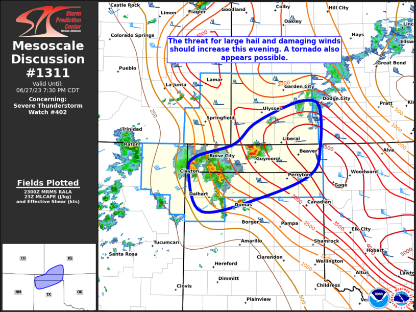
   Mesoscale Discussion 1311
   NWS Storm Prediction Center Norman OK
   0602 PM CDT Tue Jun 27 2023

   Areas affected...Portions of the OK/TX Panhandles and southwestern
   KS

   Concerning...Severe Thunderstorm Watch 402...

   Valid 272302Z - 280030Z

   The severe weather threat for Severe Thunderstorm Watch 402
   continues.

   SUMMARY...The threat for large hail and damaging winds should
   increase this evening. A tornado also appears possible.

   DISCUSSION...High-based convection that has spread from northeastern
   NM into the northern TX/OK Panhandles is beginning to intersect
   greater low-level moisture present to the east of a front. Current
   expectations are for this activity to strengthen over the next few
   hours as it encounters a moderately to strongly unstable airmass and
   40-50 kt of deep-layer shear. Supercells posing a threat for very
   large hail appear possible in the short term (next couple of hours)
   given the presence of very steep mid-level lapse rates. Convection
   should grow upscale into an intense but small bowing complex this
   evening as a southerly low-level jet gradually strengthens, with a
   focused threat for significant severe/damaging winds, some of which
   could be 75+ mph.

   A narrow window for a tornado may also exist this evening across the
   central/eastern OK Panhandle into southwest KS and vicinity, where
   LCLs are somewhat lower due to less daytime heating and
   boundary-layer mixing due to cloud cover. Low-level shear and
   hodograph curvature will increase through 01-02Z in tandem with the
   low-level jet, and any supercell that can remain discrete could
   produce a tornado across this area.

   ..Gleason.. 06/27/2023

   ...Please see www.spc.noaa.gov for graphic product...

   ATTN...WFO...DDC...AMA...

   LAT...LON   35800266 36460297 36770282 37000198 37340155 37610095
               37770041 37670007 36990005 36450027 36040140 35800266
|
|
Top/All Mesoscale Discussions/Forecast Products/Home
|
|


 @NWSSPC