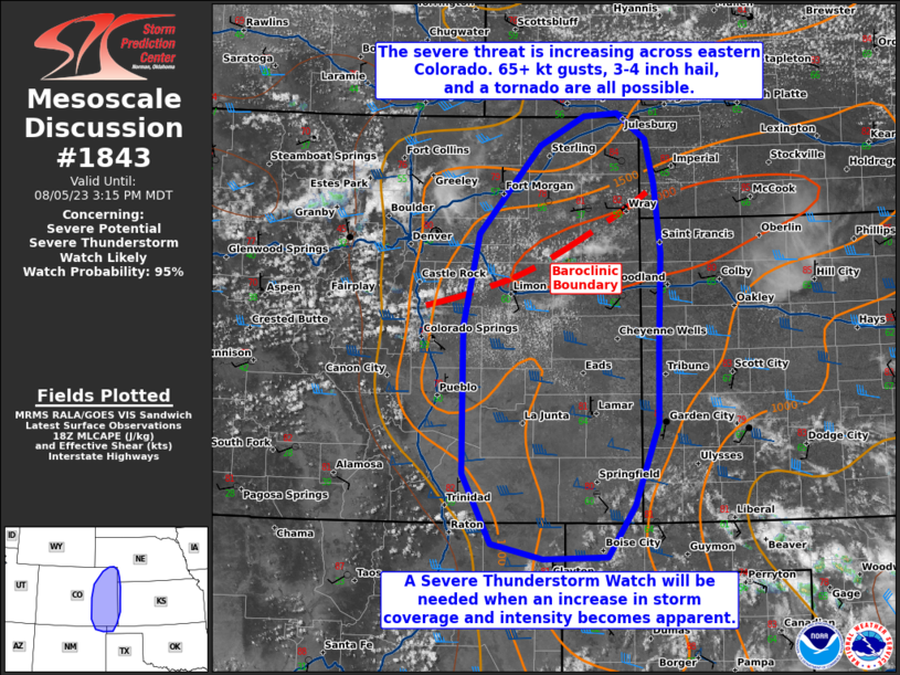
   Mesoscale Discussion 1843
   NWS Storm Prediction Center Norman OK
   0144 PM CDT Sat Aug 05 2023

   Areas affected...eastern Colorado...extreme northeast New
   Mexico...western Oklahoma Panhandle

   Concerning...Severe potential...Severe Thunderstorm Watch likely

   Valid 051844Z - 052115Z

   Probability of Watch Issuance...95 percent

   SUMMARY...The severe threat will increase through the afternoon.
   Severe wind and hail are the main threats, with 65+ kt gusts and up
   to 3-4 inch diameter hail possible. A tornado or two also cannot be
   ruled out. A Severe Thunderstorm Watch issuance will be needed when
   an uptick in convective coverage and intensity are noted.

   DISCUSSION...Mostly clear skies are in place, with surface
   temperatures exceeding 80 F amid low 60s F dewpoints. A plume of 8+
   C/km mid-level lapse rates are overspreading this warming/moistening
   boundary layer, contributing to 2000+ J/kg MLCAPE. 45+ kts of 500 mb
   westerly winds atop weak southerly low-level flow supports 40+ kts
   of effective bulk shear. The aforementioned combination of buoyancy
   and shear will support supercells as the initial convective mode.
   Given the deep-layer of steep lapse rates/high CAPE density
   profiles, elongated hodographs, and a relatively moist 700-500
   mb/2-4 km AGL hail-embryo-bearing layer (evident in pre-convective
   forecast soundings), 2+ inch diameter hail is possible with the
   stronger storms, and locally up to 3-4 inch diameter hail may occur.

   In addition, a vertical-vorticity rich stationary boundary is
   evident from Elbert to Yuma County, CO, coincident with over 100
   J/kg of 0-3 km CAPE (per 18Z mesoanalysis). As such, a landspout
   and/or a brief supercell hybrid tornado is possible with any mature,
   sustained storm that can anchor to the boundary for an appreciable
   period of time. Later this evening, storms are expected to merge
   into an MCS. Intense cold pool mergers will support a severe wind
   threat, and a couple of 65+ kt gusts could occur.

   While cumulus continue to percolate along the aforementioned
   boundary in central/northeast CO, robust convective initiation is
   not yet evident. However, the development of several storms becomes
   apparent, a Severe Thunderstorm Watch will be needed.

   ..Squitieri/Smith.. 08/05/2023

   ...Please see www.spc.noaa.gov for graphic product...

   ATTN...WFO...LBF...DDC...GLD...AMA...PUB...BOU...CYS...ABQ...

   LAT...LON   36790393 37480429 38930429 39840409 40710332 41000276
               41040233 40780198 40340187 39660179 38740181 37970183
               37170212 36650247 36640328 36790393
|


 @NWSSPC