|
| Public Severe Weather Outlook (PWO) |
|
Print Version
|
Note: During early morning hours (approximately 6am Central time), the SPC will produce a multimedia briefing MP4 file shortly after the PWO issuance. Please check back momentarily for a link to this MP4 file on this page. Please note the briefing may be out of date 5 hours after its issuance and there will be no subsequent updates during the day. Please send comments or questions to spc.feedback@noaa.gov or via the feedback page.
View What is a Watch? clip.
|

|
   ZCZC SPCPWOSPC ALL
   WOUS40 KWNS 081636
   MDZ000-NYZ000-PAZ000-WVZ000-090200-

   PUBLIC SEVERE WEATHER OUTLOOK
   NWS STORM PREDICTION CENTER NORMAN OK
   1136 AM CDT TUE JUL 08 2014

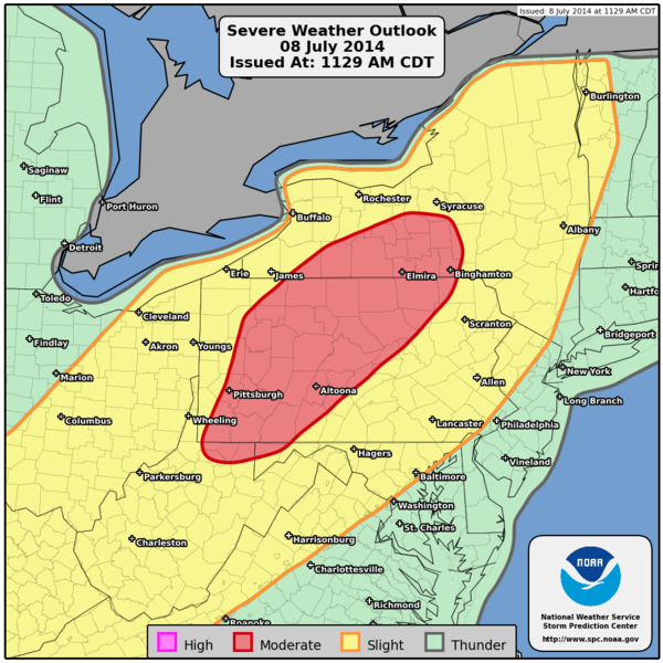
   ...Severe thunderstorms expected over parts of the north-central
   Appalachians this afternoon...

   * LOCATIONS...
     Central and western Pennsylvania
     Central and western New York
     Extreme northern West Virginia
     Western panhandle of Maryland

   * HAZARDS...
     Widespread damaging winds
     A couple of tornadoes
     Isolated large hail

   * SUMMARY...
     Severe thunderstorms capable of damaging winds and some hail
     appear likely this afternoon and evening from the Ozark Plateau
     to lower Great Lakes and western New England. Greatest
     damaging-wind threat exists in and near moderate-risk area. A
     few tornadoes may occur, especially across portions of New York
     and Pennsylvania this afternoon.

   Preparedness actions...

   Review your severe weather safety procedures for the possibility
   of dangerous weather today. Stay tuned to NOAA Weather Radio,
   weather.gov, or other media for watches and warnings. A watch
   means that conditions are favorable for severe thunderstorms
   over the next several hours. If a severe thunderstorm warning is
   issued for your area, move to a place of safety, ideally in an
   interior room on the lowest floor of a sturdy building.

   &&

   ..Edwards.. 07/08/2014

   $$
|
|
Top of Page/All Outlooks/Home
|
| Retrieving Previous PWOs |
|---|
|
|
|


