|
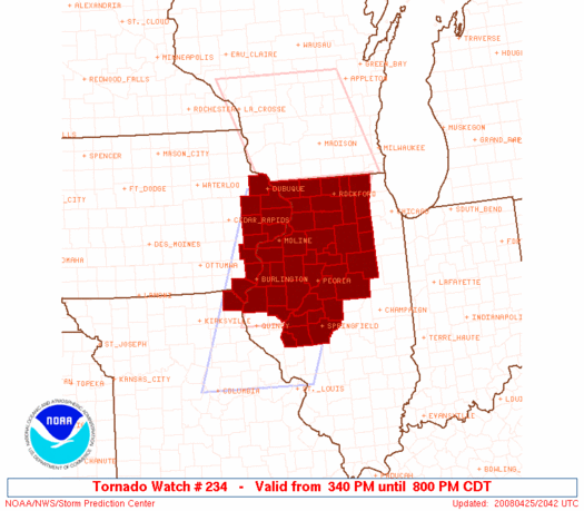
Initial List of Counties in SPC Tornado Watch 234 (WOU)
|
Back to Watch 234
|
 |
   WOUS64 KWNS 252039
   WOU4

   BULLETIN - IMMEDIATE BROADCAST REQUESTED
   TORNADO WATCH OUTLINE UPDATE FOR WT 234
   NWS STORM PREDICTION CENTER NORMAN OK
   340 PM CDT FRI APR 25 2008

   TORNADO WATCH 234 IS IN EFFECT UNTIL 800 PM CDT FOR THE
    FOLLOWING LOCATIONS

   IAC031-045-057-061-097-105-111-115-139-163-260100-
   /O.NEW.KWNS.TO.A.0234.080425T2040Z-080426T0100Z/

   IA
   .    IOWA COUNTIES INCLUDED ARE

   CEDAR                CLINTON             DES MOINES
   DUBUQUE              JACKSON             JONES
   LEE                  LOUISA              MUSCATINE
   SCOTT


   ILC007-011-015-017-037-057-063-067-071-073-085-089-093-095-099-
   103-105-107-109-111-113-123-125-129-131-137-141-143-155-161-167-
   169-171-175-177-179-187-195-201-203-260100-
   /O.NEW.KWNS.TO.A.0234.080425T2040Z-080426T0100Z/

   IL
   .    ILLINOIS COUNTIES INCLUDED ARE

   BOONE                BUREAU              CARROLL
   CASS                 DEKALB              FULTON
   GRUNDY               HANCOCK             HENDERSON
   HENRY                JO DAVIESS          KANE
   KENDALL              KNOX                LA SALLE
   LEE                  LIVINGSTON          LOGAN
   MARSHALL             MASON               MCDONOUGH
   MCHENRY              MCLEAN              MENARD
   MERCER               MORGAN              OGLE
   PEORIA               PUTNAM              ROCK ISLAND
   SANGAMON             SCHUYLER            SCOTT
   STARK                STEPHENSON          TAZEWELL
   WARREN               WHITESIDE           WINNEBAGO
   WOODFORD


   MOC045-260100-
   /O.NEW.KWNS.TO.A.0234.080425T2040Z-080426T0100Z/

   MO
   .    MISSOURI COUNTIES INCLUDED ARE

   CLARK


   ATTN...WFO...DVN...ILX...LOT...
|
| Aviation Watch (SAW) for WW234 |
|---|
 |
| Note:
The Aviation Watch (SAW) product is an approximation to the watch area.
The actual watch is depicted by the shaded areas. |
   SAW4
   WW 234 TORNADO IA IL MO 252040Z - 260100Z
   AXIS..60 STATUTE MILES EAST AND WEST OF LINE..
   25NNW RFD/ROCKFORD IL/ - 40E UIN/QUINCY IL/
   ..AVIATION COORDS.. 50NM E/W /57SW BAE - 39E UIN/
   HAIL SURFACE AND ALOFT..2 INCHES. WIND GUSTS..60 KNOTS.
   MAX TOPS TO 400. MEAN STORM MOTION VECTOR 25035.

   LAT...LON 42528811 39938930 39939158 42529047

   THIS IS AN APPROXIMATION TO THE WATCH AREA.  FOR A
   COMPLETE DEPICTION OF THE WATCH SEE WOUS64 KWNS
   FOR WOU4.
|
|


 @NWSSPC
