|
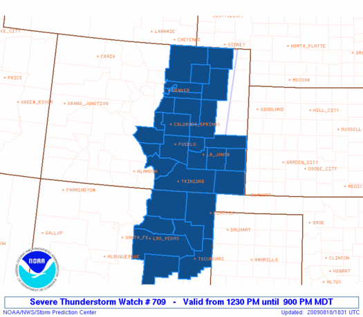
Initial List of Counties in SPC Severe Thunderstorm Watch 709 (WOU)
|
Back to Watch 709
|
 |
   WOUS64 KWNS 181826
   WOU9

   BULLETIN - IMMEDIATE BROADCAST REQUESTED
   SEVERE THUNDERSTORM WATCH OUTLINE UPDATE FOR WS 709
   NWS STORM PREDICTION CENTER NORMAN OK
   1230 PM MDT TUE AUG 18 2009

   SEVERE THUNDERSTORM WATCH 709 IS IN EFFECT UNTIL 900 PM MDT
   FOR THE FOLLOWING LOCATIONS

   COC001-005-009-011-025-027-031-035-039-041-043-055-061-071-073-
   075-087-089-099-101-119-121-123-190300-
   /O.NEW.KWNS.SV.A.0709.090818T1830Z-090819T0300Z/

   CO
   .    COLORADO COUNTIES INCLUDED ARE

   ADAMS                ARAPAHOE            BACA
   BENT                 CROWLEY             CUSTER
   DENVER               DOUGLAS             ELBERT
   EL PASO              FREMONT             HUERFANO
   KIOWA                LAS ANIMAS          LINCOLN
   LOGAN                MORGAN              OTERO
   PROWERS              PUEBLO              TELLER
   WASHINGTON           WELD


   NMC007-019-021-033-037-047-059-190300-
   /O.NEW.KWNS.SV.A.0709.090818T1830Z-090819T0300Z/

   NM
   .    NEW MEXICO COUNTIES INCLUDED ARE

   COLFAX               GUADALUPE           HARDING
   MORA                 QUAY                SAN MIGUEL
   UNION


   ATTN...WFO...BOU...ABQ...PUB...
|
| Aviation Watch (SAW) for WW709 |
|---|
 |
| Note:
The Aviation Watch (SAW) product is an approximation to the watch area.
The actual watch is depicted by the shaded areas. |
   SAW9
   WW 709 SEVERE TSTM CO NM 181830Z - 190300Z
   AXIS..60 STATUTE MILES EAST AND WEST OF LINE..
   60NNW AKO/AKRON CO/ - 40WSW TCC/TUCUMCARI NM/
   ..AVIATION COORDS.. 50NM E/W /32WSW SNY - 35WSW TCC/
   HAIL SURFACE AND ALOFT..2.5 INCHES. WIND GUSTS..60 KNOTS.
   MAX TOPS TO 500. MEAN STORM MOTION VECTOR 28020.

   LAT...LON 40970251 34950319 34950530 40970480

   THIS IS AN APPROXIMATION TO THE WATCH AREA.  FOR A
   COMPLETE DEPICTION OF THE WATCH SEE WOUS64 KWNS
   FOR WOU9.
|
|


 @NWSSPC
